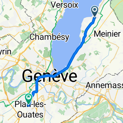
2017/006
A cycling route starting in Corsier, Canton of Geneva, Switzerland.
Overview
About this route
- -:--
- Duration
- 363.3 km
- Distance
- 1,678 m
- Ascent
- 1,672 m
- Descent
- ---
- Avg. speed
- ---
- Max. altitude
Route quality
Waytypes & surfaces along the route
Waytypes
Busy road
152.1 km
(42 %)
Quiet road
96 km
(26 %)
Surfaces
Paved
231.4 km
(64 %)
Unpaved
18.4 km
(5 %)
Asphalt
225.4 km
(62 %)
Gravel
15.2 km
(4 %)
Route highlights
Points of interest along the route
Point of interest after 89.3 km
Camping, terrain de de la Maladaire Camping Ground Route de Saint-Maurice 310
Point of interest after 180.4 km
Campsite Vermeille is a campsite in Zweisimmen, Bern, located a river/stream.The campsite has pitches with shade, pitches without shade and pitches with some shade. It is possible to rent caravans.
Continue with Bikemap
Use, edit, or download this cycling route
You would like to ride 2017/006 or customize it for your own trip? Here is what you can do with this Bikemap route:
Free features
- Save this route as favorite or in collections
- Copy & plan your own version of this route
- Split it into stages to create a multi-day tour
- Sync your route with Garmin or Wahoo
Premium features
Free trial for 3 days, or one-time payment. More about Bikemap Premium.
- Navigate this route on iOS & Android
- Export a GPX / KML file of this route
- Create your custom printout (try it for free)
- Download this route for offline navigation
Discover more Premium features.
Get Bikemap PremiumFrom our community
Other popular routes starting in Corsier
- 2017/006
- Distance
- 363.3 km
- Ascent
- 1,678 m
- Descent
- 1,672 m
- Location
- Corsier, Canton of Geneva, Switzerland
- 2017/08
- Distance
- 236 km
- Ascent
- 1,306 m
- Descent
- 1,121 m
- Location
- Corsier, Canton of Geneva, Switzerland
- Corsier - Saleve
- Distance
- 73.1 km
- Ascent
- 1,194 m
- Descent
- 1,182 m
- Location
- Corsier, Canton of Geneva, Switzerland
- Collonge-Bellerive - Avenches
- Distance
- 166.3 km
- Ascent
- 484 m
- Descent
- 441 m
- Location
- Corsier, Canton of Geneva, Switzerland
- 46.260° N 6.229° W a 46.200° N 6.176° W
- Distance
- 11.4 km
- Ascent
- 70 m
- Descent
- 83 m
- Location
- Corsier, Canton of Geneva, Switzerland
- la savonnière
- Distance
- 11.8 km
- Ascent
- 150 m
- Descent
- 73 m
- Location
- Corsier, Canton of Geneva, Switzerland
- Chemin Armand-Dufaux, Collonge-Bellerive nach Rue d'Italie, Genf
- Distance
- 10.3 km
- Ascent
- 87 m
- Descent
- 78 m
- Location
- Corsier, Canton of Geneva, Switzerland
- First Run
- Distance
- 20.4 km
- Ascent
- 164 m
- Descent
- 163 m
- Location
- Corsier, Canton of Geneva, Switzerland
Open it in the app