
Flugplatz Kaffee Latsch
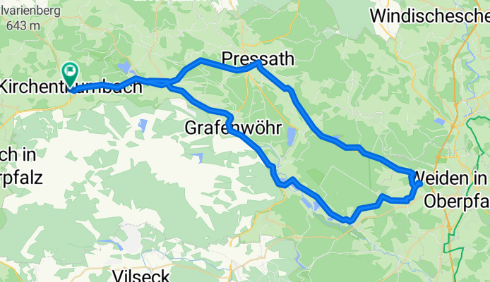
A cycling route starting in Kirchenthumbach, Bavaria, Germany.
Overview
About this route
Kirchenthumbach über Eschenbach und Grafenwöhr nach Hütten und Mantel. Über Neunkirchen und Latsch (hervorragender selbstgebackener Kuchen im Fliegerstüberl), dann Radlweg zurück.
- 4 h 33 min
- Duration
- 73.4 km
- Distance
- 282 m
- Ascent
- 282 m
- Descent
- 16.2 km/h
- Avg. speed
- ---
- Max. altitude

Route quality
Waytypes & surfaces along the route
Waytypes
Quiet road
24.2 km
(33 %)
Path
20.4 km
(28 %)
Surfaces
Paved
70.3 km
(96 %)
Unpaved
0.5 km
(<1 %)
Asphalt
70.3 km
(96 %)
Unpaved (undefined)
0.3 km
(<1 %)
Continue with Bikemap
Use, edit, or download this cycling route
You would like to ride Flugplatz Kaffee Latsch or customize it for your own trip? Here is what you can do with this Bikemap route:
Free features
- Save this route as favorite or in collections
- Copy & plan your own version of this route
- Sync your route with Garmin or Wahoo
Premium features
Free trial for 3 days, or one-time payment. More about Bikemap Premium.
- Navigate this route on iOS & Android
- Export a GPX / KML file of this route
- Create your custom printout (try it for free)
- Download this route for offline navigation
Discover more Premium features.
Get Bikemap PremiumFrom our community
Other popular routes starting in Kirchenthumbach
 Rennradtour auf sehr verkehrsarmen Wegen
- Distance
- 44.2 km
- Ascent
- 413 m
- Descent
- 414 m
- Location
- Kirchenthumbach, Bavaria, Germany
 Rundkurs Burggrub Eschenbach Natur Pur
- Distance
- 43.3 km
- Ascent
- 242 m
- Descent
- 236 m
- Location
- Kirchenthumbach, Bavaria, Germany
 Filchendorfer Runde
- Distance
- 36.7 km
- Ascent
- 366 m
- Descent
- 366 m
- Location
- Kirchenthumbach, Bavaria, Germany
 Kirchenthumbach - Destuben und zurück
- Distance
- 58.5 km
- Ascent
- 528 m
- Descent
- 528 m
- Location
- Kirchenthumbach, Bavaria, Germany
 Landkreis NEW/BT/AS einige Steigungen!
- Distance
- 36.7 km
- Ascent
- 470 m
- Descent
- 470 m
- Location
- Kirchenthumbach, Bavaria, Germany
 Armesbergrunde
- Distance
- 82.7 km
- Ascent
- 615 m
- Descent
- 610 m
- Location
- Kirchenthumbach, Bavaria, Germany
 von Kirchenthumbach zur Holzmühle in den Biergarten
- Distance
- 15.9 km
- Ascent
- 199 m
- Descent
- 196 m
- Location
- Kirchenthumbach, Bavaria, Germany
 zum Biergarten Glashütte
- Distance
- 68.8 km
- Ascent
- 556 m
- Descent
- 546 m
- Location
- Kirchenthumbach, Bavaria, Germany
Open it in the app