

Alta Tensión
A cycling route starting in Álvaro Obregón, Mexico City, Mexico.
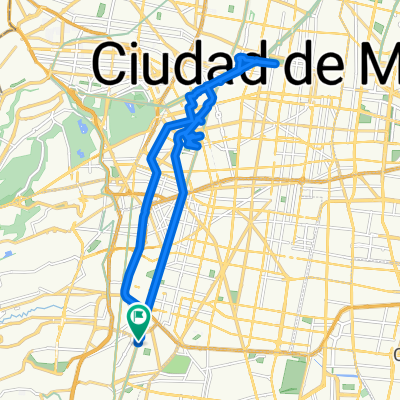
Overview
About this route
The first half is practically an uninterrupted climb, except for a couple of kilometers on flat terrain which serve as rest for the legs, undoubtedly a test of power and endurance. Before reaching the wooded area, you can simply enjoy the architectural panorama and then enjoy the forest with its scents of pine and eucalyptus; just arriving at the former convent, it's good to have a proper hydration and rest, to prepare psychologically for 40 minutes of downhill, which is explosively adrenaline-pumping.
- -:--
- Duration
- 51.4 km
- Distance
- 915 m
- Ascent
- 915 m
- Descent
- ---
- Avg. speed
- ---
- Max. altitude

Route highlights
Points of interest along the route
Point of interest after 0 km
ENCUENTRO INICIAL

Point of interest after 25.7 km
Descanso final e hidratación en el exconvento del Desierto de los Leones
Continue with Bikemap
Use, edit, or download this cycling route
You would like to ride Alta Tensión or customize it for your own trip? Here is what you can do with this Bikemap route:
Free features
- Save this route as favorite or in collections
- Copy & plan your own version of this route
- Sync your route with Garmin or Wahoo
Premium features
Free trial for 3 days, or one-time payment. More about Bikemap Premium.
- Navigate this route on iOS & Android
- Export a GPX / KML file of this route
- Create your custom printout (try it for free)
- Download this route for offline navigation
Discover more Premium features.
Get Bikemap PremiumFrom our community
Other popular routes starting in Álvaro Obregón
 Ruta desde Circuito Desnivel Mixcoac Insurgentes, Ciudad de México
- Distance
- 14.1 km
- Ascent
- 68 m
- Descent
- 73 m
- Location
- Álvaro Obregón, Mexico City, Mexico
 Revolución a Etla
- Distance
- 5.7 km
- Ascent
- 217 m
- Descent
- 247 m
- Location
- Álvaro Obregón, Mexico City, Mexico
 Circuito Interior, Benito Juárez a Avenida Río Mixcoac 66, Benito Juárez
- Distance
- 16.8 km
- Ascent
- 91 m
- Descent
- 91 m
- Location
- Álvaro Obregón, Mexico City, Mexico
 Circuito Interior (Av. Rio Mixcoac), Ciudad de México a Avenida Río Mixcoac 1–27, Ciudad de México
- Distance
- 16.5 km
- Ascent
- 96 m
- Descent
- 91 m
- Location
- Álvaro Obregón, Mexico City, Mexico
 Alta Tensión
- Distance
- 51.4 km
- Ascent
- 915 m
- Descent
- 915 m
- Location
- Álvaro Obregón, Mexico City, Mexico
 Reforma
- Distance
- 28.8 km
- Ascent
- 56 m
- Descent
- 58 m
- Location
- Álvaro Obregón, Mexico City, Mexico
 Relaxed Saturday Course In Mexico City
- Distance
- 18.3 km
- Ascent
- 92 m
- Descent
- 129 m
- Location
- Álvaro Obregón, Mexico City, Mexico
 Paseo Por Las Embajadas
- Distance
- 37 km
- Ascent
- 124 m
- Descent
- 125 m
- Location
- Álvaro Obregón, Mexico City, Mexico
Open it in the app