
Acre To Kfar Kama 18
A cycling route starting in Acre, Northern District, Israel.
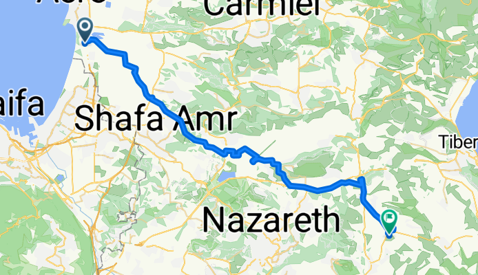
Overview
About this route
"Тятэжъмэ Яужыпкъыхэр" "In the Footsteps of the Forefathers": In memory of our ancestors
Cycling along the Circassians' route from Acre to Kfar Kama in 1878.
According to all opinions, Kfar Kama was settled in 1878. The settlers are part of the remains of the Circassian nation that survived the Russian Empire's attempt to annihilate the Circassian people..
In 1864 they were forced to abandon the Caucasus and settle in the Balkans. After 14 years in the Balkans, they were forced to leave again and reached the shores of Acre, where they stayed for a short period, and then settled in Kama.
Goals: 1. Feel and try to achieve the depth and extent of the difficulties experienced by our ancestors on their way to Kfar Kama 2. Appreciate the determination and efforts of our ancestors to ensure the continuity of the Circassian people 3. To strengthen the feeling and recognition of the commitment to this continuity
Designed for Experienced Circassian Cyclists For details: Monir Lavai - Community Center Manager 050-7235939
- -:--
- Duration
- 53.5 km
- Distance
- 332 m
- Ascent
- 143 m
- Descent
- ---
- Avg. speed
- ---
- Max. altitude
Continue with Bikemap
Use, edit, or download this cycling route
You would like to ride Acre To Kfar Kama 18 or customize it for your own trip? Here is what you can do with this Bikemap route:
Free features
- Save this route as favorite or in collections
- Copy & plan your own version of this route
- Sync your route with Garmin or Wahoo
Premium features
Free trial for 3 days, or one-time payment. More about Bikemap Premium.
- Navigate this route on iOS & Android
- Export a GPX / KML file of this route
- Create your custom printout (try it for free)
- Download this route for offline navigation
Discover more Premium features.
Get Bikemap PremiumFrom our community
Other popular routes starting in Acre
 עכו to דרך ללא שם, עין המפרץ
- Distance
- 63 km
- Ascent
- 287 m
- Descent
- 289 m
- Location
- Acre, Northern District, Israel
 עין המפרץ 20ק"מ
- Distance
- 20.4 km
- Ascent
- 56 m
- Descent
- 58 m
- Location
- Acre, Northern District, Israel
 David Noy Street 39, Acre do HaPalmach Street 71-73, Safed
- Distance
- 48.8 km
- Ascent
- 1,357 m
- Descent
- 586 m
- Location
- Acre, Northern District, Israel
 Acre To Kfar Kama 18
- Distance
- 53.5 km
- Ascent
- 332 m
- Descent
- 143 m
- Location
- Acre, Northern District, Israel
 מסעף מוסד אחווה, עכו to הראשונים 1, מטולה
- Distance
- 87.7 km
- Ascent
- 4,004 m
- Descent
- 3,503 m
- Location
- Acre, Northern District, Israel
 Unnamed Road to Yehuda Burla Street 6, Acre
- Distance
- 5.5 km
- Ascent
- 72 m
- Descent
- 49 m
- Location
- Acre, Northern District, Israel
 acres
acres- Distance
- 3.1 km
- Ascent
- 13 m
- Descent
- 20 m
- Location
- Acre, Northern District, Israel
 Ako to Roash hanikra
- Distance
- 35.3 km
- Ascent
- 89 m
- Descent
- 84 m
- Location
- Acre, Northern District, Israel
Open it in the app