

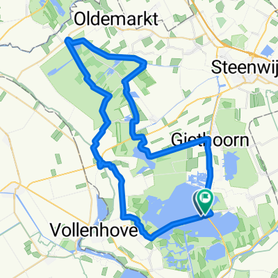
DD 6.
A cycling route starting in Wanneperveen, Overijssel, The Netherlands.
Overview
About this route
Camping de Sloothaak, Giethoorn
StadsCamping de Houtrib
- -:--
- Duration
- 65.1 km
- Distance
- 9 m
- Ascent
- 9 m
- Descent
- ---
- Avg. speed
- ---
- Max. altitude

Route quality
Waytypes & surfaces along the route
Waytypes
Cycleway
40.3 km
(62 %)
Quiet road
19.5 km
(30 %)
Surfaces
Paved
54.6 km
(84 %)
Asphalt
33.8 km
(52 %)
Concrete
20.2 km
(31 %)
Continue with Bikemap
Use, edit, or download this cycling route
You would like to ride DD 6. or customize it for your own trip? Here is what you can do with this Bikemap route:
Free features
- Save this route as favorite or in collections
- Copy & plan your own version of this route
- Sync your route with Garmin or Wahoo
Premium features
Free trial for 3 days, or one-time payment. More about Bikemap Premium.
- Navigate this route on iOS & Android
- Export a GPX / KML file of this route
- Create your custom printout (try it for free)
- Download this route for offline navigation
Discover more Premium features.
Get Bikemap PremiumFrom our community
Other popular routes starting in Wanneperveen
 giethoorn
- Distance
- 38.1 km
- Ascent
- 0 m
- Descent
- 0 m
- Location
- Wanneperveen, Overijssel, The Netherlands
 Zomerfietstocht langs het water in Steenwijkerland
- Distance
- 26.3 km
- Ascent
- 4 m
- Descent
- 4 m
- Location
- Wanneperveen, Overijssel, The Netherlands
 Giethoorn 52 km Runde
- Distance
- 51.6 km
- Ascent
- 28 m
- Descent
- 28 m
- Location
- Wanneperveen, Overijssel, The Netherlands
 Steiger Zeilkamp naar Steiger Zeilkamp
- Distance
- 36.3 km
- Ascent
- 10 m
- Descent
- 11 m
- Location
- Wanneperveen, Overijssel, The Netherlands
 DD 6.
DD 6.- Distance
- 65.1 km
- Ascent
- 9 m
- Descent
- 9 m
- Location
- Wanneperveen, Overijssel, The Netherlands
 Giethorn, 1+2
- Distance
- 54.5 km
- Ascent
- 5 m
- Descent
- 4 m
- Location
- Wanneperveen, Overijssel, The Netherlands
 awv70-NL Wiedenroute ab/bis Blauwe Hand
- Distance
- 56.5 km
- Ascent
- 6 m
- Descent
- 5 m
- Location
- Wanneperveen, Overijssel, The Netherlands
 Route in Wanneperveen
- Distance
- 33.9 km
- Ascent
- 3 m
- Descent
- 3 m
- Location
- Wanneperveen, Overijssel, The Netherlands
Open it in the app