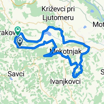
Bioterme - Gajševsko jezero - Bioterme
A cycling route starting in Sveti Tomaž, Občina Sveti Tomaž, Slovenia.
Overview
About this route
Izlet do Gajševskega jezera (ribičija in naravni rezervat za ptice, Stanjkov mlin). Lahka tura primerna tudi za otroke.
- -:--
- Duration
- 17.5 km
- Distance
- 73 m
- Ascent
- 73 m
- Descent
- ---
- Avg. speed
- ---
- Avg. speed
Route quality
Waytypes & surfaces along the route
Waytypes
Road
16.6 km
(95 %)
Track
0.4 km
(3 %)
Surfaces
Paved
15.5 km
(88 %)
Asphalt
15.5 km
(88 %)
Undefined
2 km
(12 %)
Continue with Bikemap
Use, edit, or download this cycling route
You would like to ride Bioterme - Gajševsko jezero - Bioterme or customize it for your own trip? Here is what you can do with this Bikemap route:
Free features
- Save this route as favorite or in collections
- Copy & plan your own version of this route
- Sync your route with Garmin or Wahoo
Premium features
Free trial for 3 days, or one-time payment. More about Bikemap Premium.
- Navigate this route on iOS & Android
- Export a GPX / KML file of this route
- Create your custom printout (try it for free)
- Download this route for offline navigation
Discover more Premium features.
Get Bikemap PremiumFrom our community
Other popular routes starting in Sveti Tomaž
- 2015 1004 76 km Arehova nedeljska tura
- Distance
- 75.6 km
- Ascent
- 387 m
- Descent
- 381 m
- Location
- Sveti Tomaž, Občina Sveti Tomaž, Slovenia
- Bioterme-Babičev mlin na Muri- Stara Gora-Bioterme
- Distance
- 44.6 km
- Ascent
- 254 m
- Descent
- 256 m
- Location
- Sveti Tomaž, Občina Sveti Tomaž, Slovenia
- Bioterme - Gajševsko jezero - Bioterme
- Distance
- 17.5 km
- Ascent
- 73 m
- Descent
- 73 m
- Location
- Sveti Tomaž, Občina Sveti Tomaž, Slovenia
- Pot traminca @Bioterme
- Distance
- 38.9 km
- Ascent
- 398 m
- Descent
- 398 m
- Location
- Sveti Tomaž, Občina Sveti Tomaž, Slovenia
- Lendava tour 2016 1 dan
- Distance
- 76.2 km
- Ascent
- 270 m
- Descent
- 351 m
- Location
- Sveti Tomaž, Občina Sveti Tomaž, Slovenia
- Sodinci - Jeruzalem
- Distance
- 44.8 km
- Ascent
- 666 m
- Descent
- 668 m
- Location
- Sveti Tomaž, Občina Sveti Tomaž, Slovenia
- Sveti Tomaž - stranske poti med goricami
- Distance
- 56.6 km
- Ascent
- 1,002 m
- Descent
- 986 m
- Location
- Sveti Tomaž, Občina Sveti Tomaž, Slovenia
- Sveti Tomaž - Po Prlekiji
- Distance
- 42.8 km
- Ascent
- 611 m
- Descent
- 593 m
- Location
- Sveti Tomaž, Občina Sveti Tomaž, Slovenia
Open it in the app