

Kyoto 19
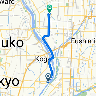
A cycling route starting in Mukō, Kyoto, Japan.
Overview
About this route
- -:--
- Duration
- 48.8 km
- Distance
- 41 m
- Ascent
- 75 m
- Descent
- ---
- Avg. speed
- ---
- Max. altitude
Route quality
Waytypes & surfaces along the route
Waytypes
Cycleway
30.7 km
(63 %)
Pedestrian area
11.2 km
(23 %)
Surfaces
Paved
9.8 km
(20 %)
Unpaved
1.5 km
(3 %)
Asphalt
8.3 km
(17 %)
Paved (undefined)
1.5 km
(3 %)
Continue with Bikemap
Use, edit, or download this cycling route
You would like to ride Kyoto 19 or customize it for your own trip? Here is what you can do with this Bikemap route:
Free features
- Save this route as favorite or in collections
- Copy & plan your own version of this route
- Sync your route with Garmin or Wahoo
Premium features
Free trial for 3 days, or one-time payment. More about Bikemap Premium.
- Navigate this route on iOS & Android
- Export a GPX / KML file of this route
- Create your custom printout (try it for free)
- Download this route for offline navigation
Discover more Premium features.
Get Bikemap PremiumFrom our community
Other popular routes starting in Mukō
 羽束師橋, 京都市へ吉祥院御池町, 京都市
- Distance
- 6.3 km
- Ascent
- 14 m
- Descent
- 7 m
- Location
- Mukō, Kyoto, Japan
 Route in Osaka
- Distance
- 9.6 km
- Ascent
- 32 m
- Descent
- 51 m
- Location
- Mukō, Kyoto, Japan
 京都市 まで27−13
- Distance
- 7 km
- Ascent
- 35 m
- Descent
- 74 m
- Location
- Mukō, Kyoto, Japan
 Kyoto - Sakurai (Keinawa cycling road)
- Distance
- 81.1 km
- Ascent
- 611 m
- Descent
- 568 m
- Location
- Mukō, Kyoto, Japan
 27−13 まで27−13
- Distance
- 13.7 km
- Ascent
- 35 m
- Descent
- 78 m
- Location
- Mukō, Kyoto, Japan
 Fushimi Inari Taisha to Kiyomizu-dera
- Distance
- 5 km
- Ascent
- 56 m
- Descent
- 17 m
- Location
- Mukō, Kyoto, Japan
 35.010, 135.682 a 34.994, 135.759
- Distance
- 10.5 km
- Ascent
- 45 m
- Descent
- 56 m
- Location
- Mukō, Kyoto, Japan
 27−5 まで京都市
- Distance
- 7.2 km
- Ascent
- 24 m
- Descent
- 61 m
- Location
- Mukō, Kyoto, Japan
Open it in the app