

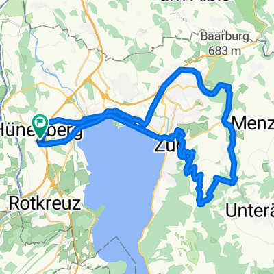
Hünenberg-Michaelskreuz-Hünenberg
A cycling route starting in Hünenberg, Canton of Zug, Switzerland.
Overview
About this route
- -:--
- Duration
- 23 km
- Distance
- 430 m
- Ascent
- 430 m
- Descent
- ---
- Avg. speed
- ---
- Max. altitude

Route quality
Waytypes & surfaces along the route
Waytypes
Road
6.1 km
(26 %)
Quiet road
5.3 km
(23 %)
Surfaces
Paved
8.8 km
(38 %)
Unpaved
0.3 km
(1 %)
Asphalt
6.8 km
(30 %)
Paved (undefined)
1.3 km
(6 %)
Continue with Bikemap
Use, edit, or download this cycling route
You would like to ride Hünenberg-Michaelskreuz-Hünenberg or customize it for your own trip? Here is what you can do with this Bikemap route:
Free features
- Save this route as favorite or in collections
- Copy & plan your own version of this route
- Sync your route with Garmin or Wahoo
Premium features
Free trial for 3 days, or one-time payment. More about Bikemap Premium.
- Navigate this route on iOS & Android
- Export a GPX / KML file of this route
- Create your custom printout (try it for free)
- Download this route for offline navigation
Discover more Premium features.
Get Bikemap PremiumFrom our community
Other popular routes starting in Hünenberg
 Hünenberg-Zug-Zugerber(via Blasenberg)-Brunegg-Höllgrotten-Zug-Hünenberg
- Distance
- 40 km
- Ascent
- 616 m
- Descent
- 610 m
- Location
- Hünenberg, Canton of Zug, Switzerland
 Hünenberg-Abtwil-Horben-Sins-Hünenberg
- Distance
- 33.3 km
- Ascent
- 552 m
- Descent
- 558 m
- Location
- Hünenberg, Canton of Zug, Switzerland
 Hünenberg-Michaelskreuz-Hünenberg
- Distance
- 23 km
- Ascent
- 430 m
- Descent
- 430 m
- Location
- Hünenberg, Canton of Zug, Switzerland
 Hünenberg-Michaelskreuz-Hünenberg
- Distance
- 24 km
- Ascent
- 1,046 m
- Descent
- 1,054 m
- Location
- Hünenberg, Canton of Zug, Switzerland
 Hünenberg - Knonau - Cham - Hünenberg
- Distance
- 24.7 km
- Ascent
- 263 m
- Descent
- 265 m
- Location
- Hünenberg, Canton of Zug, Switzerland
 Lengthy ride through Hünenberg
- Distance
- 65.5 km
- Ascent
- 569 m
- Descent
- 565 m
- Location
- Hünenberg, Canton of Zug, Switzerland
 Hünenberg - Maschwanden - Cham - Hünenberg
- Distance
- 30.1 km
- Ascent
- 234 m
- Descent
- 234 m
- Location
- Hünenberg, Canton of Zug, Switzerland
 Kleine Ausfahrt von Hünenberg
- Distance
- 21.7 km
- Ascent
- 149 m
- Descent
- 129 m
- Location
- Hünenberg, Canton of Zug, Switzerland
Open it in the app