

ALS Bike Trek MN - 2017
ALS Bike Trek MN - Short Route
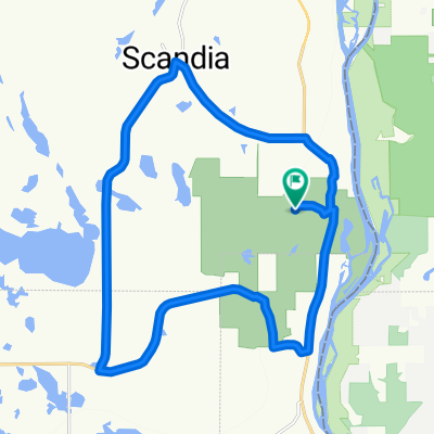
A cycling route starting in Scandia, Minnesota, United States.
Overview
About this route
2017 Short Route
- -:--
- Duration
- 23.6 km
- Distance
- 86 m
- Ascent
- 85 m
- Descent
- ---
- Avg. speed
- ---
- Max. altitude

Part of

ALS Bike Trek MN - 2017
3 stages
Route quality
Waytypes & surfaces along the route
Waytypes
Quiet road
10.1 km
(43 %)
Road
4 km
(17 %)
Surfaces
Paved
23.6 km
(100 %)
Asphalt
23.6 km
(100 %)
Route highlights
Points of interest along the route
Point of interest after 12.8 km
Rest Stop Hay Lake Picnic Shelter Restrooms Water Food and drink
Point of interest after 23.6 km
Registration
Continue with Bikemap
Use, edit, or download this cycling route
You would like to ride ALS Bike Trek MN - Short Route or customize it for your own trip? Here is what you can do with this Bikemap route:
Free features
- Save this route as favorite or in collections
- Copy & plan your own version of this route
- Sync your route with Garmin or Wahoo
Premium features
Free trial for 3 days, or one-time payment. More about Bikemap Premium.
- Navigate this route on iOS & Android
- Export a GPX / KML file of this route
- Create your custom printout (try it for free)
- Download this route for offline navigation
Discover more Premium features.
Get Bikemap PremiumFrom our community
Other popular routes starting in Scandia
 William O'Brien 15 Mile
- Distance
- 23.9 km
- Ascent
- 133 m
- Descent
- 133 m
- Location
- Scandia, Minnesota, United States
 William O'Brien 18 Mile
- Distance
- 29.5 km
- Ascent
- 218 m
- Descent
- 218 m
- Location
- Scandia, Minnesota, United States
 test nason hill
- Distance
- 65.7 km
- Ascent
- 438 m
- Descent
- 453 m
- Location
- Scandia, Minnesota, United States
 William O'Brien to Delaney Cabin
- Distance
- 42 km
- Ascent
- 177 m
- Descent
- 182 m
- Location
- Scandia, Minnesota, United States
 Scandia TT
- Distance
- 20.2 km
- Ascent
- 73 m
- Descent
- 70 m
- Location
- Scandia, Minnesota, United States
 south shore lake superior
- Distance
- 351.1 km
- Ascent
- 394 m
- Descent
- 502 m
- Location
- Scandia, Minnesota, United States
 12700–12774 Oakhill Rd N, Scandia to 10501–10649 Green Lake Trail, Chisago City
- Distance
- 9.4 km
- Ascent
- 40 m
- Descent
- 40 m
- Location
- Scandia, Minnesota, United States
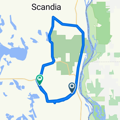
 ALS Bike Trek MN - Middle Distance Route
- Distance
- 42.8 km
- Ascent
- 135 m
- Descent
- 132 m
- Location
- Scandia, Minnesota, United States
Open it in the app