

Overview
About this route
- -:--
- Duration
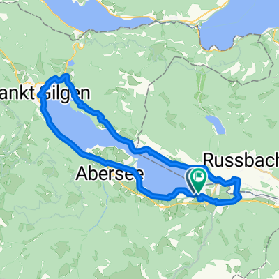
- 61.2 km
- Distance
- 565 m
- Ascent
- 565 m
- Descent
- ---
- Avg. speed
- ---
- Max. altitude

Part of
salzkammergut
1 stage
Route quality
Waytypes & surfaces along the route
Waytypes
Busy road
17.9 km
(29 %)
Quiet road
9.7 km
(16 %)
Surfaces
Paved
39.6 km
(65 %)
Unpaved
6.2 km
(10 %)
Asphalt
35.8 km
(58 %)
Gravel
5.8 km
(9 %)
Continue with Bikemap
Use, edit, or download this cycling route
You would like to ride attersee-mondsee or customize it for your own trip? Here is what you can do with this Bikemap route:
Free features
- Save this route as favorite or in collections
- Copy & plan your own version of this route
- Sync your route with Garmin or Wahoo
Premium features
Free trial for 3 days, or one-time payment. More about Bikemap Premium.
- Navigate this route on iOS & Android
- Export a GPX / KML file of this route
- Create your custom printout (try it for free)
- Download this route for offline navigation
Discover more Premium features.
Get Bikemap PremiumFrom our community
Other popular routes starting in Strobl
 Ke třem jezerům
- Distance
- 44.5 km
- Ascent
- 969 m
- Descent
- 972 m
- Location
- Strobl, Salzburg, Austria
 Postalm
- Distance
- 12.3 km
- Ascent
- 781 m
- Descent
- 261 m
- Location
- Strobl, Salzburg, Austria
 DI Seerundfahrt Wolfgangsee 32KM 600HM
- Distance
- 32.1 km
- Ascent
- 797 m
- Descent
- 795 m
- Location
- Strobl, Salzburg, Austria
 Cesta kolem 4 jezer
- Distance
- 63.4 km
- Ascent
- 529 m
- Descent
- 529 m
- Location
- Strobl, Salzburg, Austria
 42-STR-SCH-ATT-MON-WOL-STR
- Distance
- 41.6 km
- Ascent
- 686 m
- Descent
- 689 m
- Location
- Strobl, Salzburg, Austria
 Strobl_Buchberghutte_Strobl
- Distance
- 41.1 km
- Ascent
- 673 m
- Descent
- 677 m
- Location
- Strobl, Salzburg, Austria
 Strobl 1.day
- Distance
- 29.4 km
- Ascent
- 368 m
- Descent
- 365 m
- Location
- Strobl, Salzburg, Austria
 Okolo Wolfgansee II
- Distance
- 29.1 km
- Ascent
- 507 m
- Descent
- 509 m
- Location
- Strobl, Salzburg, Austria
Open it in the app