Dortmund-Ost, Route 4 von 5
A cycling route starting in Schwerte, North Rhine-Westphalia, Germany.
Overview
About this route
Die Radtour Ost ist eine Rundtour zwischen dem Westfalenpark und Holzwickede. Die Tour hat kaum Steigungen, da sie überwiegend durch das Tal der Emscher und Ihrer Nebenbäche (Lohbach, Hörder Bach) verläuft.
Ausnahme: eine starke Steigung nach Beghofen.
Start/Ziel:
Wasserschloss Haus Rodenberg
ÖPNV: U47 Endhaltestelle Aplerbeck
PKW: Parkplätze am Redenberg Einkaufzentrum
- -:--
- Duration
- 30.4 km
- Distance
- 154 m
- Ascent
- 155 m
- Descent
- ---
- Avg. speed
- 153 m
- Max. altitude
Route quality
Waytypes & surfaces along the route
Waytypes
Quiet road
15.2 km
(50 %)
Path
5.8 km
(19 %)
Surfaces
Paved
26.1 km
(86 %)
Unpaved
1.7 km
(6 %)
Asphalt
21.3 km
(70 %)
Paving stones
4.4 km
(15 %)
Route highlights
Points of interest along the route

Point of interest after 3.4 km
Rittergut Haus Sölde. Dieser Gutshof wurde erstmalig im 13. Jhd. erwähnt. Die heutigen herrschaftlichen Gebäude entstanden zwischen 1850 und 1890 und sind im Privatbesitz.

Point of interest after 7.9 km
Emscherquelle. Die 81,5km lange Emscher entspringt in Holzwickede östlich von Dortmund. Die Quelle befindet sich noch heute auf einem Hofgrundstück und speist dort einen idyllisch gelegenen Teich.

Point of interest after 20.3 km
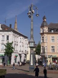
Die "Schlanke Mathilde" ist ein Nachbau (1987) eines Uhrenkandelabers von 1908 mit dem Hörder Stadtwappen. Der Platz um die "Schlanke Mathilde" ist seit jeher ein beliebter Treffpunkt.
Continue with Bikemap
Use, edit, or download this cycling route
You would like to ride Dortmund-Ost, Route 4 von 5 or customize it for your own trip? Here is what you can do with this Bikemap route:
Free features
- Save this route as favorite or in collections
- Copy & plan your own version of this route
- Sync your route with Garmin or Wahoo
Premium features
Free trial for 3 days, or one-time payment. More about Bikemap Premium.
- Navigate this route on iOS & Android
- Export a GPX / KML file of this route
- Create your custom printout (try it for free)
- Download this route for offline navigation
Discover more Premium features.
Get Bikemap PremiumFrom our community
Other popular routes starting in Schwerte
 Hausrunde
- Distance
- 50.6 km
- Ascent
- 206 m
- Descent
- 228 m
- Location
- Schwerte, North Rhine-Westphalia, Germany
 ClaudiMöhnesee
- Distance
- 49 km
- Ascent
- 238 m
- Descent
- 124 m
- Location
- Schwerte, North Rhine-Westphalia, Germany
 Ruhrtalradweg Teil 3
- Distance
- 80 km
- Ascent
- 149 m
- Descent
- 225 m
- Location
- Schwerte, North Rhine-Westphalia, Germany
 Ruhrtalradweg - 3. Etappe 12.06.2016 von Iserlohn bis Hattingen
- Distance
- 54.9 km
- Ascent
- 125 m
- Descent
- 182 m
- Location
- Schwerte, North Rhine-Westphalia, Germany
 Rund um Lanstrop andersrum
- Distance
- 61.3 km
- Ascent
- 209 m
- Descent
- 209 m
- Location
- Schwerte, North Rhine-Westphalia, Germany
 Ruhrtal Radweg (1/2)
- Distance
- 107.8 km
- Ascent
- 155 m
- Descent
- 254 m
- Location
- Schwerte, North Rhine-Westphalia, Germany
 schmetterlingsroute
- Distance
- 52.6 km
- Ascent
- 231 m
- Descent
- 232 m
- Location
- Schwerte, North Rhine-Westphalia, Germany
 Vier Talsperrenfahrt mit Sägewerk
- Distance
- 79.1 km
- Ascent
- 1,149 m
- Descent
- 1,074 m
- Location
- Schwerte, North Rhine-Westphalia, Germany
Open it in the app


