

Tour 22.04.2017
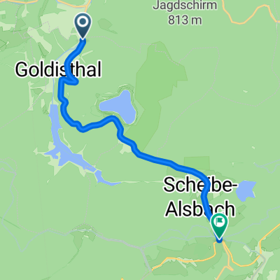
A cycling route starting in Goldisthal, Thuringia, Germany.
Overview
About this route
leicht hugelig
- -:--
- Duration
- 20.9 km
- Distance
- 350 m
- Ascent
- 344 m
- Descent
- ---
- Avg. speed
- ---
- Max. altitude
Route quality
Waytypes & surfaces along the route
Waytypes
Track
20.5 km
(98 %)
Path
0.2 km
(1 %)
Undefined
0.2 km
(1 %)
Surfaces
Paved
0.6 km
(3 %)
Unpaved
20.3 km
(97 %)
Gravel
7.7 km
(37 %)
Ground
6.9 km
(33 %)
Route highlights
Points of interest along the route

Point of interest after 5.9 km
Abfahrt nach einbiegen
Point of interest after 8.7 km
Bilder am Stausee

Point of interest after 10.4 km
Parkplatz Scheibe-Alsbach
Point of interest after 15.5 km
Breite Straße am Großparkplatz

Point of interest after 18.9 km
Breiter Weg
Continue with Bikemap
Use, edit, or download this cycling route
You would like to ride Tour 22.04.2017 or customize it for your own trip? Here is what you can do with this Bikemap route:
Free features
- Save this route as favorite or in collections
- Copy & plan your own version of this route
- Sync your route with Garmin or Wahoo
Premium features
Free trial for 3 days, or one-time payment. More about Bikemap Premium.
- Navigate this route on iOS & Android
- Export a GPX / KML file of this route
- Create your custom printout (try it for free)
- Download this route for offline navigation
Discover more Premium features.
Get Bikemap PremiumFrom our community
Other popular routes starting in Goldisthal
 Wanderung Werraquelle
- Distance
- 11.8 km
- Ascent
- 153 m
- Descent
- 153 m
- Location
- Goldisthal, Thuringia, Germany
 20150418_093854.gpx
- Distance
- 22.4 km
- Ascent
- 358 m
- Descent
- 355 m
- Location
- Goldisthal, Thuringia, Germany
 Langlauf 15.02.2015
- Distance
- 17.4 km
- Ascent
- 242 m
- Descent
- 243 m
- Location
- Goldisthal, Thuringia, Germany
 1.2.1. Skitour Friedrichshöhe-Neuhaus/Rennweg
- Distance
- 11 km
- Ascent
- 152 m
- Descent
- 143 m
- Location
- Goldisthal, Thuringia, Germany
 Goldberg 3A, Goldisthal nach Goldisthal Schule
- Distance
- 19.8 km
- Ascent
- 947 m
- Descent
- 937 m
- Location
- Goldisthal, Thuringia, Germany
 Bergzeifahren Thüringen Trainingslager
- Distance
- 9.8 km
- Ascent
- 434 m
- Descent
- 209 m
- Location
- Goldisthal, Thuringia, Germany
 Rennsteigstraße 23, Eisfeld nach Landsberger Straße, Meiningen
- Distance
- 68.5 km
- Ascent
- 427 m
- Descent
- 925 m
- Location
- Goldisthal, Thuringia, Germany
 Rennsteig Friedrichshöhe nach Neustadt
- Distance
- 34.8 km
- Ascent
- 438 m
- Descent
- 437 m
- Location
- Goldisthal, Thuringia, Germany
Open it in the app