

Феодосия - Коктебель
A cycling route starting in Koktebel, Autonomous Republic of Crimea, Ukraine.
Overview
About this route
- -:--
- Duration
- 72 km
- Distance
- 2,186 m
- Ascent
- 2,003 m
- Descent
- ---
- Avg. speed
- ---
- Max. altitude

Route highlights
Points of interest along the route
Point of interest after 2.5 km
Республиканский дельтопланерный клуб
Point of interest after 5.7 km
Центр планетарного спорта "Коктебель"

Point of interest after 6.9 km
Звездопад воспоминаний

Accommodation after 8.3 km
Ночевка №1
Point of interest after 14.5 km
Тропа Грина
Accommodation after 18.8 km
Ночевка №2 Поляна десантников

Point of interest after 22.5 km
Монастырь Сурб-Хач
Point of interest after 24.1 km
Развалины монастыря Сурб-Степанос

Point of interest after 26.8 km
Гора Френк-Мезер
Point of interest after 27.8 km
Ночевка №3 Партизанская стоянка в балке Сурхан-Дере.

Photo after 29.9 km
Пещера Алима

Point of interest after 32.4 km
Гора Сандык - Каменный лоб. Одна из самых высоких вершин в этой части Крыма.

Accommodation after 40.8 km
Ночевка №4 Под горой Урбаш

Accommodation after 49.7 km
Ночевка №5 Стоянка Эчкидаг

Photo after 51.1 km
Лисья бухта
Point of interest after 55.1 km
Катер на Биостанции
Point of interest after 63 km
Коктебель
Continue with Bikemap
Use, edit, or download this cycling route
You would like to ride Феодосия - Коктебель or customize it for your own trip? Here is what you can do with this Bikemap route:
Free features
- Save this route as favorite or in collections
- Copy & plan your own version of this route
- Sync your route with Garmin or Wahoo
Premium features
Free trial for 3 days, or one-time payment. More about Bikemap Premium.
- Navigate this route on iOS & Android
- Export a GPX / KML file of this route
- Create your custom printout (try it for free)
- Download this route for offline navigation
Discover more Premium features.
Get Bikemap PremiumFrom our community
Other popular routes starting in Koktebel
 Феодосия - Коктебель
- Distance
- 72 km
- Ascent
- 2,186 m
- Descent
- 2,003 m
- Location
- Koktebel, Autonomous Republic of Crimea, Ukraine
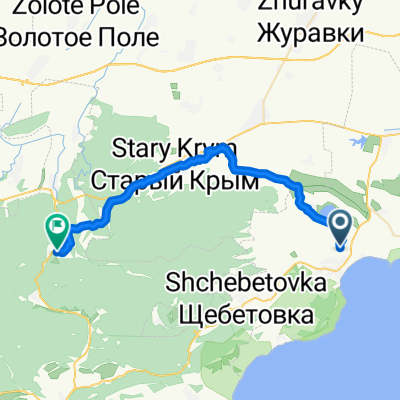 Koktebel’ - Stary Krim
- Distance
- 32.7 km
- Ascent
- 799 m
- Descent
- 394 m
- Location
- Koktebel, Autonomous Republic of Crimea, Ukraine
 От улица Морская 89, Коктебель до E97
- Distance
- 28.5 km
- Ascent
- 323 m
- Descent
- 208 m
- Location
- Koktebel, Autonomous Republic of Crimea, Ukraine
 тропа Грина
- Distance
- 8.8 km
- Ascent
- 249 m
- Descent
- 252 m
- Location
- Koktebel, Autonomous Republic of Crimea, Ukraine
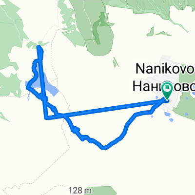
 От Unnamed Road, Наниково до Unnamed Road, Наниково
- Distance
- 3.9 km
- Ascent
- 26 m
- Descent
- 47 m
- Location
- Koktebel, Autonomous Republic of Crimea, Ukraine
 Спокойный маршрут в
- Distance
- 64.5 km
- Ascent
- 1,459 m
- Descent
- 1,456 m
- Location
- Koktebel, Autonomous Republic of Crimea, Ukraine
 Крым. Тропа Грина. Мыс Хамелеон.
- Distance
- 41.7 km
- Ascent
- 484 m
- Descent
- 726 m
- Location
- Koktebel, Autonomous Republic of Crimea, Ukraine
 Легкая езда
- Distance
- 8.2 km
- Ascent
- 93 m
- Descent
- 132 m
- Location
- Koktebel, Autonomous Republic of Crimea, Ukraine
Open it in the app