

SG60 Šentjur Arclin Šmartno Socka Frankolovo Proseniško
A cycling route starting in Šentjur pri Celju, Municipality of Šentjur, Slovenia.
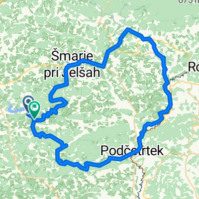
Overview
About this route
Razgibana tura po stranskih cestah, nekaj tudi makadama.
- -:--
- Duration
- 62.5 km
- Distance
- 724 m
- Ascent
- 724 m
- Descent
- ---
- Avg. speed
- ---
- Max. altitude
Route quality
Waytypes & surfaces along the route
Waytypes
Quiet road
36.2 km
(58 %)
Road
12.6 km
(20 %)
Surfaces
Paved
24.2 km
(39 %)
Unpaved
4.9 km
(8 %)
Asphalt
24 km
(38 %)
Gravel
4.9 km
(8 %)
Continue with Bikemap
Use, edit, or download this cycling route
You would like to ride SG60 Šentjur Arclin Šmartno Socka Frankolovo Proseniško or customize it for your own trip? Here is what you can do with this Bikemap route:
Free features
- Save this route as favorite or in collections
- Copy & plan your own version of this route
- Sync your route with Garmin or Wahoo
Premium features
Free trial for 3 days, or one-time payment. More about Bikemap Premium.
- Navigate this route on iOS & Android
- Export a GPX / KML file of this route
- Create your custom printout (try it for free)
- Download this route for offline navigation
Discover more Premium features.
Get Bikemap PremiumFrom our community
Other popular routes starting in Šentjur pri Celju
 Okrog Slivniškega jezera s štartom in ciljem v Šentjurju pri OŠ FM
- Distance
- 18.2 km
- Ascent
- 220 m
- Descent
- 223 m
- Location
- Šentjur pri Celju, Municipality of Šentjur, Slovenia
 Kozjanska 4
- Distance
- 59.2 km
- Ascent
- 559 m
- Descent
- 550 m
- Location
- Šentjur pri Celju, Municipality of Šentjur, Slovenia
 Kozjansko - Turistična (C)
- Distance
- 56.1 km
- Ascent
- 891 m
- Descent
- 890 m
- Location
- Šentjur pri Celju, Municipality of Šentjur, Slovenia
 Kozjansko - Panoramska (B)
- Distance
- 45.1 km
- Ascent
- 1,083 m
- Descent
- 1,082 m
- Location
- Šentjur pri Celju, Municipality of Šentjur, Slovenia
 Route to Veržej
- Distance
- 83.5 km
- Ascent
- 856 m
- Descent
- 948 m
- Location
- Šentjur pri Celju, Municipality of Šentjur, Slovenia
 Sotensko pod Kalobjem 3 nach Rifnik und zurück
- Distance
- 9.9 km
- Ascent
- 356 m
- Descent
- 357 m
- Location
- Šentjur pri Celju, Municipality of Šentjur, Slovenia
 Šentjur - Celjska koča čez Svetino, povratek čez brda nad Štorami
- Distance
- 45.3 km
- Ascent
- 811 m
- Descent
- 811 m
- Location
- Šentjur pri Celju, Municipality of Šentjur, Slovenia
 26: Planinski dom na Resevni – Planinski dom na Boču
- Distance
- 45.2 km
- Ascent
- 1,076 m
- Descent
- 1,051 m
- Location
- Šentjur pri Celju, Municipality of Šentjur, Slovenia
Open it in the app