

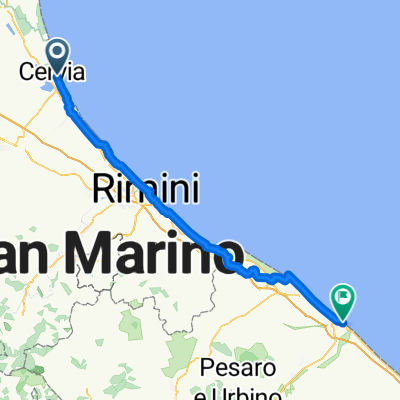
Da Cervia a Cotignola incontro alle PINK
A cycling route starting in Cervia, Emilia-Romagna, Italy.
Overview
About this route
- -:--
- Duration
- 45.1 km
- Distance
- 24 m
- Ascent
- 8 m
- Descent
- ---
- Avg. speed
- ---
- Max. altitude
Route quality
Waytypes & surfaces along the route
Waytypes
Busy road
19.9 km
(44 %)
Road
19.7 km
(44 %)
Surfaces
Paved
14.1 km
(31 %)
Unpaved
0.1 km
(<1 %)
Asphalt
14.1 km
(31 %)
Ground
0.1 km
(<1 %)
Undefined
31 km
(69 %)
Continue with Bikemap
Use, edit, or download this cycling route
You would like to ride Da Cervia a Cotignola incontro alle PINK or customize it for your own trip? Here is what you can do with this Bikemap route:
Free features
- Save this route as favorite or in collections
- Copy & plan your own version of this route
- Sync your route with Garmin or Wahoo
Premium features
Free trial for 3 days, or one-time payment. More about Bikemap Premium.
- Navigate this route on iOS & Android
- Export a GPX / KML file of this route
- Create your custom printout (try it for free)
- Download this route for offline navigation
Discover more Premium features.
Get Bikemap PremiumFrom our community
Other popular routes starting in Cervia
 Bertinoro
- Distance
- 49.7 km
- Ascent
- 242 m
- Descent
- 226 m
- Location
- Cervia, Emilia-Romagna, Italy
 CERVIA
- Distance
- 65.9 km
- Ascent
- 58 m
- Descent
- 56 m
- Location
- Cervia, Emilia-Romagna, Italy
 Milano M. argine Bevano e Savio
- Distance
- 46.3 km
- Ascent
- 10 m
- Descent
- 12 m
- Location
- Cervia, Emilia-Romagna, Italy
 Ironman Italy
- Distance
- 91.5 km
- Ascent
- 200 m
- Descent
- 197 m
- Location
- Cervia, Emilia-Romagna, Italy
 ludo di classe
- Distance
- 5.8 km
- Ascent
- 10 m
- Descent
- 9 m
- Location
- Cervia, Emilia-Romagna, Italy
 IRONMAN Italy Emilia-Romagna, Cervia 2020
- Distance
- 11.4 km
- Ascent
- 9 m
- Descent
- 9 m
- Location
- Cervia, Emilia-Romagna, Italy
 Cervia-Misano Adriatico
- Distance
- 49.4 km
- Ascent
- 30 m
- Descent
- 27 m
- Location
- Cervia, Emilia-Romagna, Italy
 Cervia - Fano
- Distance
- 86.8 km
- Ascent
- 488 m
- Descent
- 490 m
- Location
- Cervia, Emilia-Romagna, Italy
Open it in the app