

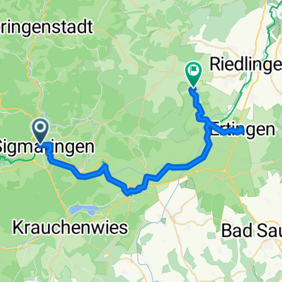
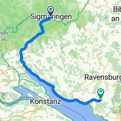
04. Etappe Sigmaringen-Ulm
A cycling route starting in Sigmaringen, Baden-Wurttemberg, Germany.
Overview
About this route
- -:--
- Duration
- 96.7 km
- Distance
- 146 m
- Ascent
- 237 m
- Descent
- ---
- Avg. speed
- ---
- Max. altitude

Route quality
Waytypes & surfaces along the route
Waytypes
Track
39.7 km
(41 %)
Quiet road
20.3 km
(21 %)
Surfaces
Paved
79.3 km
(82 %)
Unpaved
9.7 km
(10 %)
Asphalt
77.4 km
(80 %)
Loose gravel
4.8 km
(5 %)
Continue with Bikemap
Use, edit, or download this cycling route
You would like to ride 04. Etappe Sigmaringen-Ulm or customize it for your own trip? Here is what you can do with this Bikemap route:
Free features
- Save this route as favorite or in collections
- Copy & plan your own version of this route
- Split it into stages to create a multi-day tour
- Sync your route with Garmin or Wahoo
Premium features
Free trial for 3 days, or one-time payment. More about Bikemap Premium.
- Navigate this route on iOS & Android
- Export a GPX / KML file of this route
- Create your custom printout (try it for free)
- Download this route for offline navigation
Discover more Premium features.
Get Bikemap PremiumFrom our community
Other popular routes starting in Sigmaringen
 19. Sigmaringen-Riedsee/Donaueschingen (izvor Dunava)
- Distance
- 86.6 km
- Ascent
- 1,358 m
- Descent
- 1,256 m
- Location
- Sigmaringen, Baden-Wurttemberg, Germany
 From Sigmaringen to Altheim
- Distance
- 38.7 km
- Ascent
- 269 m
- Descent
- 279 m
- Location
- Sigmaringen, Baden-Wurttemberg, Germany
 Ulm Straßburg
- Distance
- 363.4 km
- Ascent
- 1,227 m
- Descent
- 1,228 m
- Location
- Sigmaringen, Baden-Wurttemberg, Germany
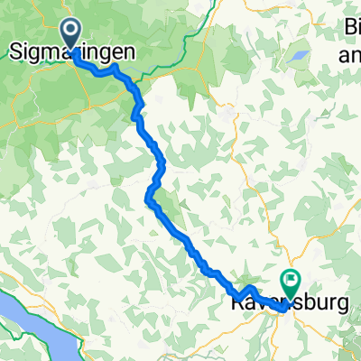 Von Sigmaringen bis Ravensburg
- Distance
- 64.7 km
- Ascent
- 547 m
- Descent
- 668 m
- Location
- Sigmaringen, Baden-Wurttemberg, Germany
 Sigmaringen/Riedlingen
- Distance
- 35.6 km
- Ascent
- 103 m
- Descent
- 195 m
- Location
- Sigmaringen, Baden-Wurttemberg, Germany
 Donauradweg von Sigmaringen nach Ulm
- Distance
- 95.8 km
- Ascent
- 488 m
- Descent
- 596 m
- Location
- Sigmaringen, Baden-Wurttemberg, Germany
 Sigmaringen Heudorf Bingen Runde
- Distance
- 39.9 km
- Ascent
- 277 m
- Descent
- 273 m
- Location
- Sigmaringen, Baden-Wurttemberg, Germany
 RoGüPe Tag2
- Distance
- 100.7 km
- Ascent
- 811 m
- Descent
- 927 m
- Location
- Sigmaringen, Baden-Wurttemberg, Germany
Open it in the app