
2016-12-03 08:11
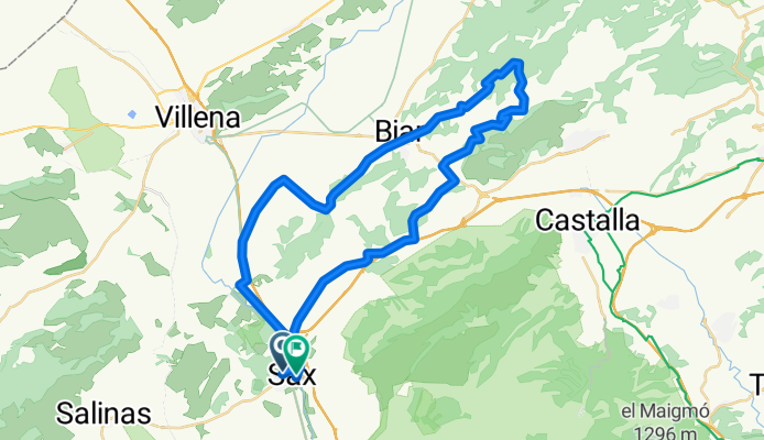
A cycling route starting in Sax, Valencia, Spain.
Overview
About this route
Hora Inicio: 12/03/2016 08:11 Hora Fin: 12/03/2016 13:17 Distancia recorrida: 47,2 km (05:05) Tiempo en movimiento: 04:24 Velocidad media: 9,26 km/h Vel. en Mov.: 10,7 km/h Velocidad Máxima: 55,49km/h Altura Mínima: 413 m Altura Máxima: 975 m Velocidad Ascenso: 571 m/h Velocidad Descenso: -1147,6 m/h Ganancia Altitud: 1331 m Pérdida Altitud: -1303 m Tiempo Ascenso: 02:19 Tiempo Descenso: 01:08
- -:--
- Duration
- 48.2 km
- Distance
- 750 m
- Ascent
- 766 m
- Descent
- ---
- Avg. speed
- ---
- Max. altitude
Continue with Bikemap
Use, edit, or download this cycling route
You would like to ride 2016-12-03 08:11 or customize it for your own trip? Here is what you can do with this Bikemap route:
Free features
- Save this route as favorite or in collections
- Copy & plan your own version of this route
- Sync your route with Garmin or Wahoo
Premium features
Free trial for 3 days, or one-time payment. More about Bikemap Premium.
- Navigate this route on iOS & Android
- Export a GPX / KML file of this route
- Create your custom printout (try it for free)
- Download this route for offline navigation
Discover more Premium features.
Get Bikemap PremiumFrom our community
Other popular routes starting in Sax
 L'Alt Vinalopó: Sax-colònia de Santa Eulàlia-Sax
- Distance
- 15.1 km
- Ascent
- 95 m
- Descent
- 98 m
- Location
- Sax, Valencia, Spain
 Sax Taguenca ALCOY Vía Verde Sax
- Distance
- 86.3 km
- Ascent
- 872 m
- Descent
- 886 m
- Location
- Sax, Valencia, Spain
 paraje de sax castalla zona del ave
- Distance
- 23.2 km
- Ascent
- 230 m
- Descent
- 235 m
- Location
- Sax, Valencia, Spain
 Girolibero: Costa Blanca
- Distance
- 189.7 km
- Ascent
- 612 m
- Descent
- 1,064 m
- Location
- Sax, Valencia, Spain
 Sax-Las En cebras-La Algueña-La Romana-Sax
- Distance
- 69.8 km
- Ascent
- 538 m
- Descent
- 552 m
- Location
- Sax, Valencia, Spain
 Entrenamiento
- Distance
- 21.3 km
- Ascent
- 182 m
- Descent
- 170 m
- Location
- Sax, Valencia, Spain
 Sax-Biar-Patiras-Benejama-Sax
- Distance
- 56.3 km
- Ascent
- 518 m
- Descent
- 530 m
- Location
- Sax, Valencia, Spain
 buena
buena- Distance
- 151 km
- Ascent
- 1,153 m
- Descent
- 1,148 m
- Location
- Sax, Valencia, Spain
Open it in the app