

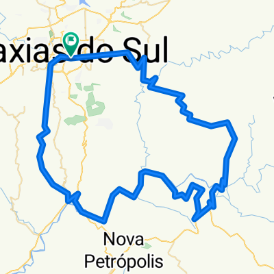
Farroupilha-NovaSardemnha-Buratti-SaoPedro-Caravagio
A cycling route starting in Caxias do Sul, Rio Grande do Sul, Brazil.
Overview
About this route
Farroupilha-NovaSardemnha-Buratti-SaoPedro-Caravagio
- -:--
- Duration
- 87.9 km
- Distance
- 912 m
- Ascent
- 938 m
- Descent
- ---
- Avg. speed
- ---
- Max. altitude

Continue with Bikemap
Use, edit, or download this cycling route
You would like to ride Farroupilha-NovaSardemnha-Buratti-SaoPedro-Caravagio or customize it for your own trip? Here is what you can do with this Bikemap route:
Free features
- Save this route as favorite or in collections
- Copy & plan your own version of this route
- Split it into stages to create a multi-day tour
- Sync your route with Garmin or Wahoo
Premium features
Free trial for 3 days, or one-time payment. More about Bikemap Premium.
- Navigate this route on iOS & Android
- Export a GPX / KML file of this route
- Create your custom printout (try it for free)
- Download this route for offline navigation
Discover more Premium features.
Get Bikemap PremiumFrom our community
Other popular routes starting in Caxias do Sul
 Loreto-ValeReal-Chuchu-ArroioPaixão-Belo
- Distance
- 106.8 km
- Ascent
- 1,503 m
- Descent
- 1,499 m
- Location
- Caxias do Sul, Rio Grande do Sul, Brazil
 CarlosBarbosa-Barão-SVendelino-Canastra-Casa
- Distance
- 116.1 km
- Ascent
- 1,322 m
- Descent
- 1,312 m
- Location
- Caxias do Sul, Rio Grande do Sul, Brazil
 Caxias-Flores-NPadua-NRoma-Bento-Jansen
- Distance
- 120.1 km
- Ascent
- 1,479 m
- Descent
- 1,480 m
- Location
- Caxias do Sul, Rio Grande do Sul, Brazil
 SaltoVentoso-LMuller-Blauth-Burati-Farroupilha-Casa
- Distance
- 74.1 km
- Ascent
- 707 m
- Descent
- 707 m
- Location
- Caxias do Sul, Rio Grande do Sul, Brazil
 Ana Rech/Fazenda Souza/Vila Seca/Faxinal
- Distance
- 38.5 km
- Ascent
- 677 m
- Descent
- 678 m
- Location
- Caxias do Sul, Rio Grande do Sul, Brazil
 Pedalada rumo a vovozinha!👵👵
- Distance
- 103.1 km
- Ascent
- 486 m
- Descent
- 1,208 m
- Location
- Caxias do Sul, Rio Grande do Sul, Brazil
 LGonçalvesDias-LBrasil-SãoMaximiliano-SantaLúcia
- Distance
- 107.5 km
- Ascent
- 1,896 m
- Descent
- 1,896 m
- Location
- Caxias do Sul, Rio Grande do Sul, Brazil
 caminho ponte das antas
- Distance
- 64.3 km
- Ascent
- 530 m
- Descent
- 1,033 m
- Location
- Caxias do Sul, Rio Grande do Sul, Brazil
Open it in the app