
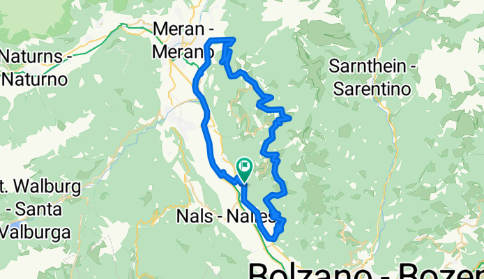
Vilpian-Rennrad Rundtour
A cycling route starting in Gargazon, Trentino-Alto Adige, Italy.
Overview
About this route
- -:--
- Duration
- 56.8 km
- Distance
- 1,347 m
- Ascent
- 1,349 m
- Descent
- ---
- Avg. speed
- ---
- Avg. speed
Route quality
Waytypes & surfaces along the route
Waytypes
Busy road
33.1 km
(58 %)
Quiet road
6.5 km
(11 %)
Surfaces
Paved
52.8 km
(93 %)
Unpaved
1.4 km
(3 %)
Asphalt
51.3 km
(90 %)
Paved (undefined)
1.6 km
(3 %)
Continue with Bikemap
Use, edit, or download this cycling route
You would like to ride Vilpian-Rennrad Rundtour or customize it for your own trip? Here is what you can do with this Bikemap route:
Free features
- Save this route as favorite or in collections
- Copy & plan your own version of this route
- Sync your route with Garmin or Wahoo
Premium features
Free trial for 3 days, or one-time payment. More about Bikemap Premium.
- Navigate this route on iOS & Android
- Export a GPX / KML file of this route
- Create your custom printout (try it for free)
- Download this route for offline navigation
Discover more Premium features.
Get Bikemap PremiumFrom our community
Other popular routes starting in Gargazon
 Meranerstraße
- Distance
- 53.3 km
- Ascent
- 284 m
- Descent
- 284 m
- Location
- Gargazon, Trentino-Alto Adige, Italy
 Tour 05, Südtiroler Weinstrasse 1
- Distance
- 43.7 km
- Ascent
- 213 m
- Descent
- 213 m
- Location
- Gargazon, Trentino-Alto Adige, Italy
 Gargazone Seiser Alm
- Distance
- 128.9 km
- Ascent
- 1,976 m
- Descent
- 1,980 m
- Location
- Gargazon, Trentino-Alto Adige, Italy
 Da Via Stazione 37, Gargazzone a Via Nicolò Rasmo 83, Bolzano
- Distance
- 16.6 km
- Ascent
- 81 m
- Descent
- 113 m
- Location
- Gargazon, Trentino-Alto Adige, Italy
 Bahnhofstraße 37, Gargazon nach MeBo 45, Bolzano
- Distance
- 13.9 km
- Ascent
- 4 m
- Descent
- 1 m
- Location
- Gargazon, Trentino-Alto Adige, Italy
 Bahnhofstraße 37, Gargazon nach SS 38, Gargazon
- Distance
- 0.4 km
- Ascent
- 0 m
- Descent
- 0 m
- Location
- Gargazon, Trentino-Alto Adige, Italy
 Vilpian-Rennrad Rundtour
- Distance
- 56.8 km
- Ascent
- 1,347 m
- Descent
- 1,349 m
- Location
- Gargazon, Trentino-Alto Adige, Italy
 Tag 9 - Von Gargazon nach Meran Bahnhof
- Distance
- 12.3 km
- Ascent
- 68 m
- Descent
- 27 m
- Location
- Gargazon, Trentino-Alto Adige, Italy
Open it in the app