

Colli Berici ed Euganei 2017
A cycling route starting in Lonigo, Veneto, Italy.
Overview
About this route
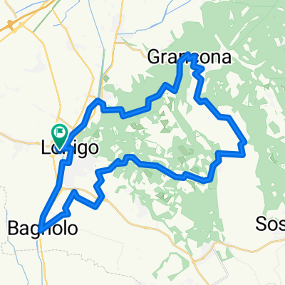
Partenza da Lonigo. Salitelle nei monti berici fino a Zovencedo per poi spianare verso i Colli Euganei. Salita da Teolo fino al Monte Venta, punto più alto dei Colli Euganei, discesa verso Galzignano Terme, Valsanzibio (villa) e poi Arquà Petrarca, perla dei colli, Monselice, Este, Lozzo Atestino, Sossano, Orgiano, Lonigo
- -:--
- Duration
- 115.8 km
- Distance
- 1,154 m
- Ascent
- 1,163 m
- Descent
- ---
- Avg. speed
- ---
- Max. altitude

Route quality
Waytypes & surfaces along the route
Waytypes
Busy road
36.2 km
(31 %)
Quiet road
32 km
(28 %)
Surfaces
Paved
87.7 km
(76 %)
Unpaved
13.1 km
(11 %)
Asphalt
86.5 km
(75 %)
Ground
7.8 km
(7 %)
Continue with Bikemap
Use, edit, or download this cycling route
You would like to ride Colli Berici ed Euganei 2017 or customize it for your own trip? Here is what you can do with this Bikemap route:
Free features
- Save this route as favorite or in collections
- Copy & plan your own version of this route
- Split it into stages to create a multi-day tour
- Sync your route with Garmin or Wahoo
Premium features
Free trial for 3 days, or one-time payment. More about Bikemap Premium.
- Navigate this route on iOS & Android
- Export a GPX / KML file of this route
- Create your custom printout (try it for free)
- Download this route for offline navigation
Discover more Premium features.
Get Bikemap PremiumFrom our community
Other popular routes starting in Lonigo
 alonte
- Distance
- 37.4 km
- Ascent
- 343 m
- Descent
- 346 m
- Location
- Lonigo, Veneto, Italy
 Lonigo/villa favorita Sarego
- Distance
- 16.7 km
- Ascent
- 41 m
- Descent
- 38 m
- Location
- Lonigo, Veneto, Italy
 GIRO MTB1
- Distance
- 9.3 km
- Ascent
- 176 m
- Descent
- 230 m
- Location
- Lonigo, Veneto, Italy
 MTB1
MTB1- Distance
- 22.3 km
- Ascent
- 272 m
- Descent
- 272 m
- Location
- Lonigo, Veneto, Italy
 Giro medio Colli Berici
- Distance
- 46.5 km
- Ascent
- 954 m
- Descent
- 954 m
- Location
- Lonigo, Veneto, Italy
 lonigo/grancona lungo
- Distance
- 35.6 km
- Ascent
- 525 m
- Descent
- 522 m
- Location
- Lonigo, Veneto, Italy
 Alta via dei berici Lonigo/alonte/sarego
- Distance
- 35.9 km
- Ascent
- 650 m
- Descent
- 650 m
- Location
- Lonigo, Veneto, Italy
 Lonigo Rocca Pisana
- Distance
- 29.7 km
- Ascent
- 472 m
- Descent
- 474 m
- Location
- Lonigo, Veneto, Italy
Open it in the app