

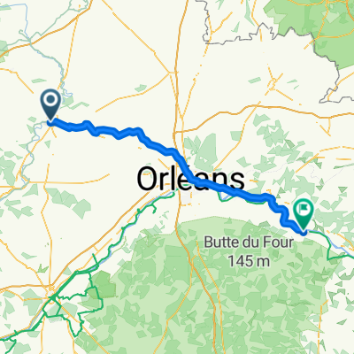
day 5
A cycling route starting in Châteaudun, Centre-Val de Loire, France.
Overview
About this route
chateudaun to who knows
- -:--
- Duration
- 103.4 km
- Distance
- 101 m
- Ascent
- 130 m
- Descent
- ---
- Avg. speed
- ---
- Max. altitude

Route quality
Waytypes & surfaces along the route
Waytypes
Quiet road
28.2 km
(27 %)
Busy road
26.6 km
(26 %)
Surfaces
Paved
40.2 km
(39 %)
Unpaved
12.7 km
(12 %)
Asphalt
35.7 km
(35 %)
Ground
6.8 km
(7 %)
Continue with Bikemap
Use, edit, or download this cycling route
You would like to ride day 5 or customize it for your own trip? Here is what you can do with this Bikemap route:
Free features
- Save this route as favorite or in collections
- Copy & plan your own version of this route
- Split it into stages to create a multi-day tour
- Sync your route with Garmin or Wahoo
Premium features
Free trial for 3 days, or one-time payment. More about Bikemap Premium.
- Navigate this route on iOS & Android
- Export a GPX / KML file of this route
- Create your custom printout (try it for free)
- Download this route for offline navigation
Discover more Premium features.
Get Bikemap PremiumFrom our community
Other popular routes starting in Châteaudun
 chateaudun
- Distance
- 120.5 km
- Ascent
- 503 m
- Descent
- 503 m
- Location
- Châteaudun, Centre-Val de Loire, France
 Lisbon to Paris - Day 20
- Distance
- 117.9 km
- Ascent
- 201 m
- Descent
- 198 m
- Location
- Châteaudun, Centre-Val de Loire, France
 Châteaudun- Chateauroux mai 2019
- Distance
- 177.8 km
- Ascent
- 298 m
- Descent
- 288 m
- Location
- Châteaudun, Centre-Val de Loire, France
 day 5
day 5- Distance
- 103.4 km
- Ascent
- 101 m
- Descent
- 130 m
- Location
- Châteaudun, Centre-Val de Loire, France
 COMPOSTELA 13
- Distance
- 47.2 km
- Ascent
- 118 m
- Descent
- 151 m
- Location
- Châteaudun, Centre-Val de Loire, France
 Châteaudun-Loches-Bellac-Souillac 460 km - 2200 m
- Distance
- 460.3 km
- Ascent
- 1,047 m
- Descent
- 1,083 m
- Location
- Châteaudun, Centre-Val de Loire, France
 EU 18 _ Chateaudun - Vendome _ 57 km
- Distance
- 56.3 km
- Ascent
- 176 m
- Descent
- 203 m
- Location
- Châteaudun, Centre-Val de Loire, France
 Recovered Route
- Distance
- 37.2 km
- Ascent
- 135 m
- Descent
- 145 m
- Location
- Châteaudun, Centre-Val de Loire, France
Open it in the app