
erste Tour
A cycling route starting in Wördern, Lower Austria, Austria.
Overview
About this route
TAHUNA track
- -:--
- Duration
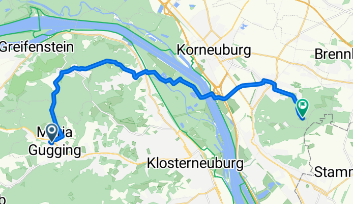
- 15.3 km
- Distance
- 445 m
- Ascent
- 331 m
- Descent
- ---
- Avg. speed
- ---
- Max. altitude

Route quality
Waytypes & surfaces along the route
Waytypes
Track
8 km
(52 %)
Quiet road
3.8 km
(25 %)
Surfaces
Paved
4.3 km
(28 %)
Unpaved
8.7 km
(57 %)
Ground
4.4 km
(29 %)
Asphalt
4.3 km
(28 %)
Route highlights
Points of interest along the route
Point of interest after 0 km
f1f0f1 Maria Gugging ist ein Ort und eine Katastralgemeinde von Klosterneuburg in Niederösterreich. Erstmals urkundlich erwähnt wurde Gugging („Kukkingin“) vermutlich 1072 bzw. „Gukkindorf“ 1083. Bereits aus der Jungsteinzeit gibt es menschliche Spuren in und um Maria Gugging. Handfeste Beweise für
Continue with Bikemap
Use, edit, or download this cycling route
You would like to ride erste Tour or customize it for your own trip? Here is what you can do with this Bikemap route:
Free features
- Save this route as favorite or in collections
- Copy & plan your own version of this route
- Sync your route with Garmin or Wahoo
Premium features
Free trial for 3 days, or one-time payment. More about Bikemap Premium.
- Navigate this route on iOS & Android
- Export a GPX / KML file of this route
- Create your custom printout (try it for free)
- Download this route for offline navigation
Discover more Premium features.
Get Bikemap PremiumFrom our community
Other popular routes starting in Wördern
 28042018 Wördern Dopplerhütte
- Distance
- 25.1 km
- Ascent
- 312 m
- Descent
- 309 m
- Location
- Wördern, Lower Austria, Austria
 erste Tour
- Distance
- 15.3 km
- Ascent
- 445 m
- Descent
- 331 m
- Location
- Wördern, Lower Austria, Austria
 IST - Hadersfeld - Weidlingbach - Mauerbach - Neustift - home
- Distance
- 63.9 km
- Ascent
- 820 m
- Descent
- 874 m
- Location
- Wördern, Lower Austria, Austria
 Wördern - Bratislava
- Distance
- 109.5 km
- Ascent
- 397 m
- Descent
- 446 m
- Location
- Wördern, Lower Austria, Austria
 Heiligenstadt_St.AndräWördner_Donauroute_2016
- Distance
- 22.5 km
- Ascent
- 79 m
- Descent
- 88 m
- Location
- Wördern, Lower Austria, Austria
 Greifenstein - Hadersfeld - Kahlenberg
- Distance
- 20.6 km
- Ascent
- 604 m
- Descent
- 446 m
- Location
- Wördern, Lower Austria, Austria
 Greifenstein Hadersfeld Kierling Scheiblingstein Mauerbach Kirchstetten Greifenstein
- Distance
- 54.9 km
- Ascent
- 1,207 m
- Descent
- 1,226 m
- Location
- Wördern, Lower Austria, Austria
 IST - Herzogenburg - Tiefenfucha
- Distance
- 70.9 km
- Ascent
- 766 m
- Descent
- 735 m
- Location
- Wördern, Lower Austria, Austria
Open it in the app