
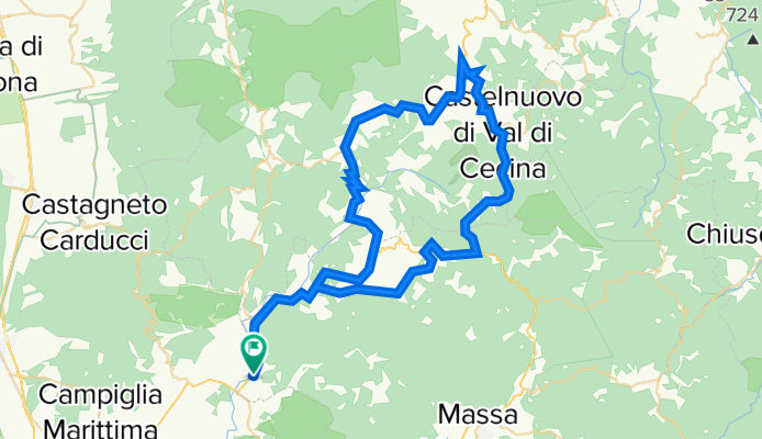
Larderello és a Biancane nemzeti park
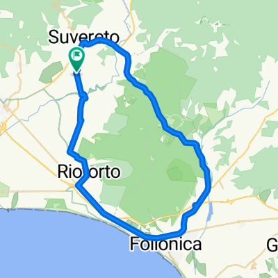
A cycling route starting in Suvereto, Tuscany, Italy.
Overview
About this route
Ez a túra egy nagyon érdekes geotermikus nemzeti parkba visz el bennünket, a Biancane geotermikus parkba, kiegészítve Larderellóval, a geotermikus erőműközponttal és múzeummal. A túra otthonról indul, a szállásról jobbra kikanyarodva egyből egy gyönyörű, hullámos tájra érünk, az út kicsit emelkedik, de észre sem venni, gyönyörű erdőkön keresztül fogunk haladni. Nem megyünk egyből a parkba, hanem a dombok, hegyek közt, azokra feltekerve, kisvárosokat érintve, Lustignano és Serrazzano, érkezünk meg Larderelloba. Megnézzük a múzeumot, majd továbbmegyünk Castelnuovo di Val di Cecina felé (rövid emelkedő). Innen érünk el Monterotondo Marittimoba, ahol a Biancane nemzeti park van. A park a város szélén található. Sétálunk egy jót, majd hazaindulunk egy nagyon kellemes, hullámos uton, alapvetően hazáig gurulunk.
- -:--
- Duration
- 75 km
- Distance
- 1,058 m
- Ascent
- 1,058 m
- Descent
- ---
- Avg. speed
- ---
- Max. altitude
Route quality
Waytypes & surfaces along the route
Waytypes
Busy road
50.6 km
(68 %)
Road
18.4 km
(25 %)
Surfaces
Paved
43 km
(57 %)
Unpaved
1 km
(1 %)
Asphalt
43 km
(57 %)
Unpaved (undefined)
0.7 km
(<1 %)
Continue with Bikemap
Use, edit, or download this cycling route
You would like to ride Larderello és a Biancane nemzeti park or customize it for your own trip? Here is what you can do with this Bikemap route:
Free features
- Save this route as favorite or in collections
- Copy & plan your own version of this route
- Sync your route with Garmin or Wahoo
Premium features
Free trial for 3 days, or one-time payment. More about Bikemap Premium.
- Navigate this route on iOS & Android
- Export a GPX / KML file of this route
- Create your custom printout (try it for free)
- Download this route for offline navigation
Discover more Premium features.
Get Bikemap PremiumFrom our community
Other popular routes starting in Suvereto
 Biancane geotermikus park (Massa Marittima)
- Distance
- 66.3 km
- Ascent
- 847 m
- Descent
- 846 m
- Location
- Suvereto, Tuscany, Italy
 Larderello és a Biancane nemzeti park
- Distance
- 75 km
- Ascent
- 1,058 m
- Descent
- 1,058 m
- Location
- Suvereto, Tuscany, Italy
 Da Località San Michele 49, Suvereto a Località San Michele 49, Suvereto
- Distance
- 47.7 km
- Ascent
- 255 m
- Descent
- 268 m
- Location
- Suvereto, Tuscany, Italy
 Sassetta-Monteverdi-Bolgheri 90Km / 1000Hm
- Distance
- 90.3 km
- Ascent
- 832 m
- Descent
- 841 m
- Location
- Suvereto, Tuscany, Italy
 Massa Marittima kör
- Distance
- 50 km
- Ascent
- 588 m
- Descent
- 591 m
- Location
- Suvereto, Tuscany, Italy
 Tour Agliail
- Distance
- 32.8 km
- Ascent
- 413 m
- Descent
- 410 m
- Location
- Suvereto, Tuscany, Italy
 Von Monterotondo Marittimo bis Suvereto
- Distance
- 31 km
- Ascent
- 957 m
- Descent
- 946 m
- Location
- Suvereto, Tuscany, Italy
 suverto - monteverdi-sassetta- bellvedere"max"
- Distance
- 48.4 km
- Ascent
- 1,050 m
- Descent
- 1,111 m
- Location
- Suvereto, Tuscany, Italy
Open it in the app