

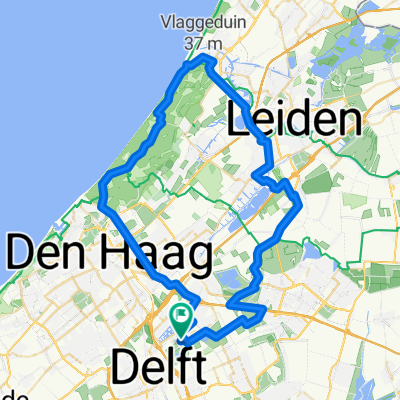
Nootdorp - Vlaardingsevaart.gpx
A cycling route starting in Ypenburg, South Holland, The Netherlands.
Overview
About this route
TAHUNA track
- -:--
- Duration
- 44.4 km
- Distance
- 4 m
- Ascent
- 4 m
- Descent
- ---
- Avg. speed
- ---
- Max. altitude
Route quality
Waytypes & surfaces along the route
Waytypes
Cycleway
23.1 km
(52 %)
Quiet road
18.2 km
(41 %)
Road
3.1 km
(7 %)
Surfaces
Paved
35.1 km
(79 %)
Unpaved
0.4 km
(1 %)
Asphalt
34.7 km
(78 %)
Paved (undefined)
0.4 km
(1 %)
Continue with Bikemap
Use, edit, or download this cycling route
You would like to ride Nootdorp - Vlaardingsevaart.gpx or customize it for your own trip? Here is what you can do with this Bikemap route:
Free features
- Save this route as favorite or in collections
- Copy & plan your own version of this route
- Sync your route with Garmin or Wahoo
Premium features
Free trial for 3 days, or one-time payment. More about Bikemap Premium.
- Navigate this route on iOS & Android
- Export a GPX / KML file of this route
- Create your custom printout (try it for free)
- Download this route for offline navigation
Discover more Premium features.
Get Bikemap PremiumFrom our community
Other popular routes starting in Ypenburg
 Nootdorp - Vlaardingsevaart.gpx
- Distance
- 44.4 km
- Ascent
- 4 m
- Descent
- 4 m
- Location
- Ypenburg, South Holland, The Netherlands
 Groene Hart
- Distance
- 104.6 km
- Ascent
- 0 m
- Descent
- 0 m
- Location
- Ypenburg, South Holland, The Netherlands
 rondje den haag
- Distance
- 58.6 km
- Ascent
- 50 m
- Descent
- 47 m
- Location
- Ypenburg, South Holland, The Netherlands
 Duinenmars
- Distance
- 62.3 km
- Ascent
- 44 m
- Descent
- 44 m
- Location
- Ypenburg, South Holland, The Netherlands
 hoekmerenroute
- Distance
- 99.3 km
- Ascent
- 14 m
- Descent
- 12 m
- Location
- Ypenburg, South Holland, The Netherlands
 Nootdorp rotte via moerkapelle
- Distance
- 49.2 km
- Ascent
- 0 m
- Descent
- 0 m
- Location
- Ypenburg, South Holland, The Netherlands
 test
test- Distance
- 78.9 km
- Ascent
- 4 m
- Descent
- 4 m
- Location
- Ypenburg, South Holland, The Netherlands
 Ypenburg, Pijncker, Nesselande, Rottemeren, Zoetermeer, Leidschenveen, Ypenburg
- Distance
- 47.9 km
- Ascent
- 0 m
- Descent
- 0 m
- Location
- Ypenburg, South Holland, The Netherlands
Open it in the app