

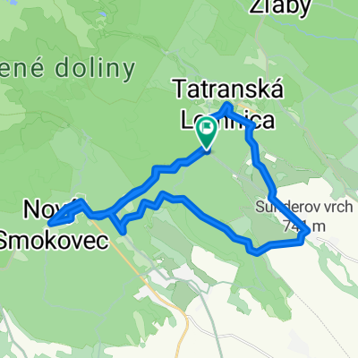
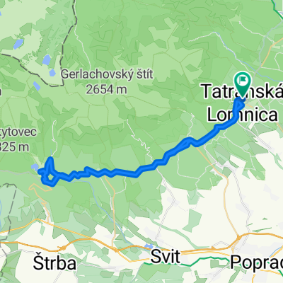
Tatranská Lomnica - Zelené pleso
A cycling route starting in Vysoké Tatry, Prešov Region, Slovakia.
Overview
About this route
Asfalt - cesty, polne / lesne cesty
- -:--
- Duration
- 10.9 km
- Distance
- 719 m
- Ascent
- 25 m
- Descent
- ---
- Avg. speed
- 1,547 m
- Max. altitude

Route quality
Waytypes & surfaces along the route
Waytypes
Track
7.6 km
(70 %)
Road
0.1 km
(1 %)
Surfaces
Paved
3.3 km
(30 %)
Unpaved
7.6 km
(70 %)
Rock
4.5 km
(41 %)
Asphalt
3.3 km
(30 %)
Gravel
3.2 km
(29 %)
Continue with Bikemap
Use, edit, or download this cycling route
You would like to ride Tatranská Lomnica - Zelené pleso or customize it for your own trip? Here is what you can do with this Bikemap route:
Free features
- Save this route as favorite or in collections
- Copy & plan your own version of this route
- Sync your route with Garmin or Wahoo
Premium features
Free trial for 3 days, or one-time payment. More about Bikemap Premium.
- Navigate this route on iOS & Android
- Export a GPX / KML file of this route
- Create your custom printout (try it for free)
- Download this route for offline navigation
Discover more Premium features.
Get Bikemap PremiumFrom our community
Other popular routes starting in Vysoké Tatry
 ALPOK EXPEDÍCIÓ (2015) -1. nap - Szombat
- Distance
- 215.9 km
- Ascent
- 2,013 m
- Descent
- 2,358 m
- Location
- Vysoké Tatry, Prešov Region, Slovakia
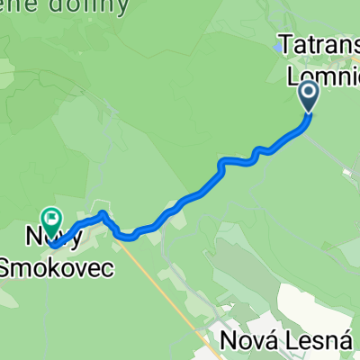 Cesta 537, Vysoké Tatry až Nový Smokovec, Vysoké Tatry
- Distance
- 6.4 km
- Ascent
- 181 m
- Descent
- 9 m
- Location
- Vysoké Tatry, Prešov Region, Slovakia
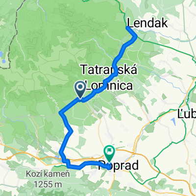 Starý Smokovec, Vysoké Tatry až Traktorová, Poprad
- Distance
- 52.4 km
- Ascent
- 633 m
- Descent
- 951 m
- Location
- Vysoké Tatry, Prešov Region, Slovakia
 Stará Lesná, Stará Lesná až Stará Lesná, Stará Lesná
- Distance
- 81.9 km
- Ascent
- 1,826 m
- Descent
- 1,825 m
- Location
- Vysoké Tatry, Prešov Region, Slovakia
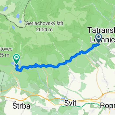 Tátralomnic, Magastátra - Szentiványho, Csorba
- Distance
- 20 km
- Ascent
- 580 m
- Descent
- 147 m
- Location
- Vysoké Tatry, Prešov Region, Slovakia
 Cesta 3102, Vysoké Tatry až Tatranská Lesná, Vysoké Tatry
- Distance
- 29.9 km
- Ascent
- 513 m
- Descent
- 512 m
- Location
- Vysoké Tatry, Prešov Region, Slovakia
 sobota
- Distance
- 86.9 km
- Ascent
- 0 m
- Descent
- 0 m
- Location
- Vysoké Tatry, Prešov Region, Slovakia
 Tátralomnic, Magastátra - Tátralomnic, Magastátra
- Distance
- 47.1 km
- Ascent
- 829 m
- Descent
- 827 m
- Location
- Vysoké Tatry, Prešov Region, Slovakia
Open it in the app