

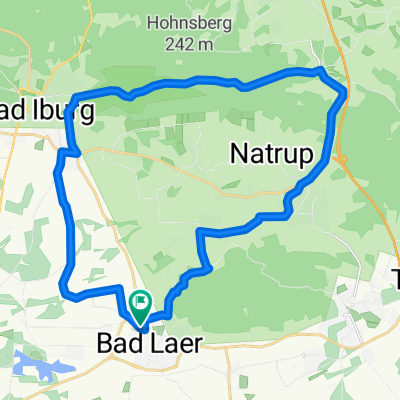
Bad Laer 1
A cycling route starting in Bad Laer, Lower Saxony, Germany.
Overview
About this route
- -:--
- Duration
- 57.8 km
- Distance
- 396 m
- Ascent
- 398 m
- Descent
- ---
- Avg. speed
- ---
- Max. altitude

Route quality
Waytypes & surfaces along the route
Waytypes
Quiet road
24.2 km
(42 %)
Path
10.9 km
(19 %)
Surfaces
Paved
39.6 km
(68 %)
Unpaved
4.1 km
(7 %)
Asphalt
34.1 km
(59 %)
Paving stones
3 km
(5 %)
Route highlights
Points of interest along the route

Photo after 1.2 km
Conny´s Backstube

Photo after 5.5 km
Landschaftgestaltung

Photo after 7.1 km
Kurmittelhaus Bad Rothenfelde

Photo after 7.2 km
Die große Saline in Bad Rothenfelde

Photo after 10.5 km
Rathaus

Photo after 10.5 km
Fachwerk Ensemble

Photo after 13.5 km
Rehquelle

Photo after 14 km
Große Rehquelle

Photo after 14.6 km
Waldschänke

Photo after 15.2 km
Schwarze Welle / Almaquelle

Photo after 16.4 km
Hasefurt

Photo after 16.5 km
Hasequelle

Photo after 17.4 km
Morgennebel

Photo after 18.6 km
St. Bartholomäus vor Strecke anzeigen

Photo after 18.8 km
Beutlingsallee

Photo after 19.7 km
Kirche Bartholomäus

Photo after 22 km
Aussichtsturm auf dem Beutling

Photo after 23.8 km
Melle-Nüven Fachwerkgiebel

Photo after 28.5 km
Kirche Matthäus

Photo after 28.7 km
Ziel Melle Marktplatz

Photo after 28.7 km
Melle

Photo after 30.1 km
Dampfgenerator

Photo after 34 km
Schloß Gesmold
Point of interest after 34 km
Schloss Gesmold

Photo after 34 km
Schloß Gesmold - Orangerie

Photo after 34 km
Schloss Gesmold

Photo after 37.7 km
Bifurkation Hase-Else

Photo after 37.9 km
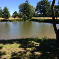
Wassertretstelle

Photo after 41.6 km
Borgloh Heiligenhäuschen an den Uphöfen

Photo after 43.9 km
Kirche von Borgloh

Photo after 48.1 km
Kunst am Bauernhof in Hilter

Photo after 49.9 km
Kriegerehrenmal mit Eichen am Ahornweg nähe Hilter a TW

Photo after 51 km
Hilter

Photo after 51.2 km
Hilter, ev.-luth. Kirche St. Johannes der Täufer

Photo after 56.6 km
Blick vom Blomberg

Photo after 57.5 km
Alte Wassermühle
Continue with Bikemap
Use, edit, or download this cycling route
You would like to ride Bad Laer 1 or customize it for your own trip? Here is what you can do with this Bikemap route:
Free features
- Save this route as favorite or in collections
- Copy & plan your own version of this route
- Sync your route with Garmin or Wahoo
Premium features
Free trial for 3 days, or one-time payment. More about Bikemap Premium.
- Navigate this route on iOS & Android
- Export a GPX / KML file of this route
- Create your custom printout (try it for free)
- Download this route for offline navigation
Discover more Premium features.
Get Bikemap PremiumFrom our community
Other popular routes starting in Bad Laer
 Bad Laer nach Vinnenberg, Bad Laer
- Distance
- 43.7 km
- Ascent
- 69 m
- Descent
- 69 m
- Location
- Bad Laer, Lower Saxony, Germany
 CE091122
- Distance
- 25.5 km
- Ascent
- 200 m
- Descent
- 200 m
- Location
- Bad Laer, Lower Saxony, Germany
 Kleine Runde
- Distance
- 43.7 km
- Ascent
- 94 m
- Descent
- 94 m
- Location
- Bad Laer, Lower Saxony, Germany
 Bad Laer-Vinnenberg -Bad Laer
- Distance
- 48.2 km
- Ascent
- 53 m
- Descent
- 56 m
- Location
- Bad Laer, Lower Saxony, Germany
 Grenzgängertour 1.Tag
- Distance
- 46 km
- Ascent
- 105 m
- Descent
- 126 m
- Location
- Bad Laer, Lower Saxony, Germany
 Bad Laer 1
- Distance
- 57.8 km
- Ascent
- 396 m
- Descent
- 398 m
- Location
- Bad Laer, Lower Saxony, Germany
 Rundtour von Bad Laer - Halle , mit einer Cafepause im Cafe Beuken Schmedt
- Distance
- 60.3 km
- Ascent
- 102 m
- Descent
- 100 m
- Location
- Bad Laer, Lower Saxony, Germany
 Bad Lear über Osnabrück, Hasbergen Lengerich (Friedensroute) zurück nach Bad Laer über Lienen
- Distance
- 79.1 km
- Ascent
- 573 m
- Descent
- 574 m
- Location
- Bad Laer, Lower Saxony, Germany
Open it in the app