

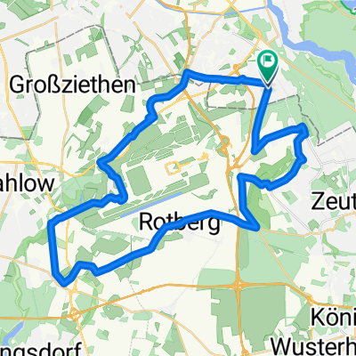
MTB Runde Rauchfangwerder
A cycling route starting in Bohnsdorf, State of Berlin, Germany.
Overview
About this route
MTB Runde in den letzten Zipfel von Berlin - auch hier fährt noch die BVG :-)
- -:--
- Duration
- 37.8 km
- Distance
- 98 m
- Ascent
- 98 m
- Descent
- ---
- Avg. speed
- ---
- Max. altitude
Continue with Bikemap
Use, edit, or download this cycling route
You would like to ride MTB Runde Rauchfangwerder or customize it for your own trip? Here is what you can do with this Bikemap route:
Free features
- Save this route as favorite or in collections
- Copy & plan your own version of this route
- Sync your route with Garmin or Wahoo
Premium features
Free trial for 3 days, or one-time payment. More about Bikemap Premium.
- Navigate this route on iOS & Android
- Export a GPX / KML file of this route
- Create your custom printout (try it for free)
- Download this route for offline navigation
Discover more Premium features.
Get Bikemap PremiumFrom our community
Other popular routes starting in Bohnsdorf
 Prieborner Straße 29, Berlin nach Prieborner Straße 29, Berlin
- Distance
- 8 km
- Ascent
- 16 m
- Descent
- 20 m
- Location
- Bohnsdorf, State of Berlin, Germany
 I tappa Hotel Grunau - Stazione Jungfernheide
- Distance
- 49.7 km
- Ascent
- 70 m
- Descent
- 76 m
- Location
- Bohnsdorf, State of Berlin, Germany
 Dahme - Seddinsee
- Distance
- 37.6 km
- Ascent
- 135 m
- Descent
- 138 m
- Location
- Bohnsdorf, State of Berlin, Germany
 MTB Runde Rauchfangwerder
- Distance
- 37.8 km
- Ascent
- 98 m
- Descent
- 98 m
- Location
- Bohnsdorf, State of Berlin, Germany
 zuhause Mauerweg Lichtenrade
- Distance
- 14.1 km
- Ascent
- 22 m
- Descent
- 17 m
- Location
- Bohnsdorf, State of Berlin, Germany
 Unbenannte Route
- Distance
- 42.1 km
- Ascent
- 99 m
- Descent
- 98 m
- Location
- Bohnsdorf, State of Berlin, Germany
 Wegendorf
- Distance
- 40.3 km
- Ascent
- 71 m
- Descent
- 40 m
- Location
- Bohnsdorf, State of Berlin, Germany
 Prieborner Straße 29, Berlin nach Hans-Schmidt-Straße 10, Berlin
- Distance
- 10.2 km
- Ascent
- 18 m
- Descent
- 29 m
- Location
- Bohnsdorf, State of Berlin, Germany
Open it in the app