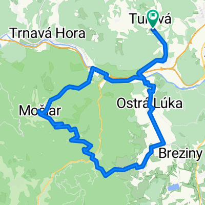
SOFTIP CYKLO TOUR 2017 - Softipácka 25ka
A cycling route starting in Zvolen, Banská Bystrica Region, Slovakia.
Overview
About this route
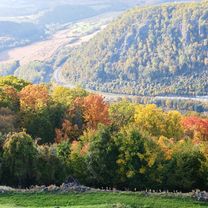
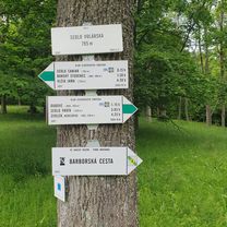
Hronsek - Vlkanová - Peťovská dolina - Iliaš - Mičinské lúky {PIT STOP} Dúbrava - Zadná Hrabová - Géciovský majer - Hronsek
- -:--
- Duration
- 25.3 km
- Distance
- 473 m
- Ascent
- 471 m
- Descent
- ---
- Avg. speed
- ---
- Max. altitude
Route quality
Waytypes & surfaces along the route
Waytypes
Track
21.6 km
(85 %)
Quiet road
3.3 km
(13 %)
Surfaces
Paved
3.5 km
(14 %)
Unpaved
18.4 km
(73 %)
Unpaved (undefined)
11.8 km
(47 %)
Gravel
3.5 km
(14 %)
Route highlights
Points of interest along the route
Point of interest after 3.5 km
SOFTIP CYKLO TOUR 2017 Fort Geronimo
Point of interest after 18 km
SOFTIP CYKLO TOUR 2017 {PIT STOP}
Continue with Bikemap
Use, edit, or download this cycling route
You would like to ride SOFTIP CYKLO TOUR 2017 - Softipácka 25ka or customize it for your own trip? Here is what you can do with this Bikemap route:
Free features
- Save this route as favorite or in collections
- Copy & plan your own version of this route
- Sync your route with Garmin or Wahoo
Premium features
Free trial for 3 days, or one-time payment. More about Bikemap Premium.
- Navigate this route on iOS & Android
- Export a GPX / KML file of this route
- Create your custom printout (try it for free)
- Download this route for offline navigation
Discover more Premium features.
Get Bikemap PremiumFrom our community
Other popular routes starting in Zvolen
- Zvolen - Sekier - Čertove Kúty - Vígľ.Huta / Kalinka
- Distance
- 18 km
- Ascent
- 538 m
- Descent
- 289 m
- Location
- Zvolen, Banská Bystrica Region, Slovakia
- Malý lesný okruh
- Distance
- 31 km
- Ascent
- 724 m
- Descent
- 724 m
- Location
- Zvolen, Banská Bystrica Region, Slovakia
- 7. Bacúrov-Zvolen (turistická trasa)
- Distance
- 16.2 km
- Ascent
- 434 m
- Descent
- 592 m
- Location
- Zvolen, Banská Bystrica Region, Slovakia
- SOFTIP CYKLO TOUR 2017 - Softipácka 25ka
- Distance
- 25.3 km
- Ascent
- 473 m
- Descent
- 471 m
- Location
- Zvolen, Banská Bystrica Region, Slovakia
- SOFTIP CYKLO TOUR 2017 - Vlčkov Extrém
- Distance
- 32 km
- Ascent
- 618 m
- Descent
- 618 m
- Location
- Zvolen, Banská Bystrica Region, Slovakia
- Okolo priehrady
- Distance
- 8.2 km
- Ascent
- 176 m
- Descent
- 147 m
- Location
- Zvolen, Banská Bystrica Region, Slovakia
- Štiavnické vrchy - Hronská Breznica - Močiar - Podhorie - Banská Belá - Hronská Breznica
- Distance
- 34.3 km
- Ascent
- 596 m
- Descent
- 596 m
- Location
- Zvolen, Banská Bystrica Region, Slovakia
- Pred jarkami, Veľká Lúka do Pred jarkami, Veľká Lúka
- Distance
- 43.9 km
- Ascent
- 621 m
- Descent
- 600 m
- Location
- Zvolen, Banská Bystrica Region, Slovakia
Open it in the app