

Obereuerheim Hahnenhügel
A cycling route starting in Kolitzheim, Bavaria, Germany.
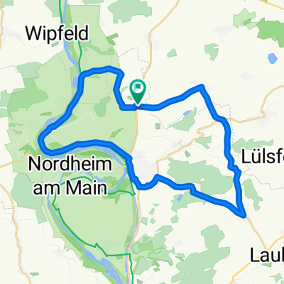
Overview
About this route
Tour on 06.05.2017
- -:--
- Duration
- 44.7 km
- Distance
- 138 m
- Ascent
- 135 m
- Descent
- ---
- Avg. speed
- ---
- Max. altitude

Route quality
Waytypes & surfaces along the route
Waytypes
Track
21 km
(47 %)
Quiet road
11.6 km
(26 %)
Surfaces
Paved
30.8 km
(69 %)
Unpaved
6.3 km
(14 %)
Asphalt
17.9 km
(40 %)
Paved (undefined)
11.6 km
(26 %)
Continue with Bikemap
Use, edit, or download this cycling route
You would like to ride Obereuerheim Hahnenhügel or customize it for your own trip? Here is what you can do with this Bikemap route:
Free features
- Save this route as favorite or in collections
- Copy & plan your own version of this route
- Sync your route with Garmin or Wahoo
Premium features
Free trial for 3 days, or one-time payment. More about Bikemap Premium.
- Navigate this route on iOS & Android
- Export a GPX / KML file of this route
- Create your custom printout (try it for free)
- Download this route for offline navigation
Discover more Premium features.
Get Bikemap PremiumFrom our community
Other popular routes starting in Kolitzheim
 Zeilitzheim Münnerstadt Kreuzberg 2020
- Distance
- 98.3 km
- Ascent
- 945 m
- Descent
- 248 m
- Location
- Kolitzheim, Bavaria, Germany
 Hundelshausen - Theinheim
- Distance
- 33.5 km
- Ascent
- 210 m
- Descent
- 132 m
- Location
- Kolitzheim, Bavaria, Germany
 Berg Wipfeld Stammheim
- Distance
- 32.7 km
- Ascent
- 108 m
- Descent
- 106 m
- Location
- Kolitzheim, Bavaria, Germany
 Kreuzberg 2019 Variante 2
- Distance
- 99.6 km
- Ascent
- 1,050 m
- Descent
- 351 m
- Location
- Kolitzheim, Bavaria, Germany
 Unter- Ober- Mittelfranken Tour
- Distance
- 195.7 km
- Ascent
- 443 m
- Descent
- 439 m
- Location
- Kolitzheim, Bavaria, Germany
 Falkenstein
- Distance
- 39.1 km
- Ascent
- 145 m
- Descent
- 149 m
- Location
- Kolitzheim, Bavaria, Germany
 Morgenrunde
- Distance
- 31.6 km
- Ascent
- 206 m
- Descent
- 204 m
- Location
- Kolitzheim, Bavaria, Germany
 Obereuerheim Hahnenhügel
- Distance
- 44.7 km
- Ascent
- 138 m
- Descent
- 135 m
- Location
- Kolitzheim, Bavaria, Germany
Open it in the app