

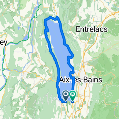
MONT du CHAT, por Le Bourget du Lac
A cycling route starting in Le Bourget-du-Lac, Auvergne-Rhône-Alpes, France.
Overview
About this route
Climb.
- -:--
- Duration
- 13.6 km
- Distance
- 1,254 m
- Ascent
- 0 m
- Descent
- ---
- Avg. speed
- ---
- Max. altitude

Route quality
Waytypes & surfaces along the route
Waytypes
Road
12.2 km
(90 %)
Track
1.4 km
(10 %)
Surfaces
Paved
12.2 km
(90 %)
Unpaved
1.4 km
(10 %)
Asphalt
12.2 km
(90 %)
Ground
1.4 km
(10 %)
Continue with Bikemap
Use, edit, or download this cycling route
You would like to ride MONT du CHAT, por Le Bourget du Lac or customize it for your own trip? Here is what you can do with this Bikemap route:
Free features
- Save this route as favorite or in collections
- Copy & plan your own version of this route
- Sync your route with Garmin or Wahoo
Premium features
Free trial for 3 days, or one-time payment. More about Bikemap Premium.
- Navigate this route on iOS & Android
- Export a GPX / KML file of this route
- Create your custom printout (try it for free)
- Download this route for offline navigation
Discover more Premium features.
Get Bikemap PremiumFrom our community
Other popular routes starting in Le Bourget-du-Lac
 Mont du Chat via Col du Chat
- Distance
- 68.4 km
- Ascent
- 1,961 m
- Descent
- 1,960 m
- Location
- Le Bourget-du-Lac, Auvergne-Rhône-Alpes, France
 opdecahier_lacdubourget2004_04
- Distance
- 71.8 km
- Ascent
- 1,782 m
- Descent
- 1,173 m
- Location
- Le Bourget-du-Lac, Auvergne-Rhône-Alpes, France
 INES- Entre Deux Guiers via col de l'Epine
- Distance
- 53.3 km
- Ascent
- 1,155 m
- Descent
- 1,001 m
- Location
- Le Bourget-du-Lac, Auvergne-Rhône-Alpes, France
 INES- Entre Deux Guiers via l'antenne du chat
- Distance
- 59 km
- Ascent
- 1,627 m
- Descent
- 1,473 m
- Location
- Le Bourget-du-Lac, Auvergne-Rhône-Alpes, France
 Bourget
- Distance
- 49.5 km
- Ascent
- 670 m
- Descent
- 672 m
- Location
- Le Bourget-du-Lac, Auvergne-Rhône-Alpes, France
 boulot_Aix_AR_piste_cyclable
- Distance
- 21.6 km
- Ascent
- 13 m
- Descent
- 12 m
- Location
- Le Bourget-du-Lac, Auvergne-Rhône-Alpes, France
 MONT du CHAT, por Le Bourget du Lac
- Distance
- 13.6 km
- Ascent
- 1,254 m
- Descent
- 0 m
- Location
- Le Bourget-du-Lac, Auvergne-Rhône-Alpes, France
 Tour France_ Ambérieu-en-Bugey - Le Mont du Chat
- Distance
- 206.7 km
- Ascent
- 2,916 m
- Descent
- 4,117 m
- Location
- Le Bourget-du-Lac, Auvergne-Rhône-Alpes, France
Open it in the app