

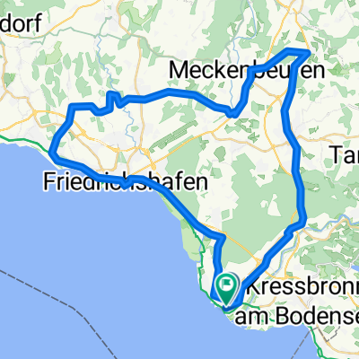
Lange Radrunde durch Langenargen
A cycling route starting in Langenargen, Baden-Wurttemberg, Germany.
Overview
About this route
- -:--
- Duration
- 52.3 km
- Distance
- 47 m
- Ascent
- 47 m
- Descent
- ---
- Avg. speed
- ---
- Max. altitude
Route highlights
Points of interest along the route

Photo after 0 km

Photo after 27.2 km
Point of interest after 27.2 km
Continue with Bikemap
Use, edit, or download this cycling route
You would like to ride Lange Radrunde durch Langenargen or customize it for your own trip? Here is what you can do with this Bikemap route:
Free features
- Save this route as favorite or in collections
- Copy & plan your own version of this route
- Sync your route with Garmin or Wahoo
Premium features
Free trial for 3 days, or one-time payment. More about Bikemap Premium.
- Navigate this route on iOS & Android
- Export a GPX / KML file of this route
- Create your custom printout (try it for free)
- Download this route for offline navigation
Discover more Premium features.
Get Bikemap PremiumFrom our community
Other popular routes starting in Langenargen
 Langenargen Schleinseee Wasserburg
- Distance
- 17.6 km
- Ascent
- 187 m
- Descent
- 183 m
- Location
- Langenargen, Baden-Wurttemberg, Germany
 Im Wassersportzentrum, Kressbronn am Bodensee nach Belruptstraße, Bregenz
- Distance
- 59.3 km
- Ascent
- 634 m
- Descent
- 621 m
- Location
- Langenargen, Baden-Wurttemberg, Germany
 Eichendorffstraße, Langenargen to Eichendorffstraße, Langenargen
- Distance
- 50.1 km
- Ascent
- 244 m
- Descent
- 241 m
- Location
- Langenargen, Baden-Wurttemberg, Germany
 Bodensee 2
- Distance
- 76.6 km
- Ascent
- 581 m
- Descent
- 583 m
- Location
- Langenargen, Baden-Wurttemberg, Germany
 Camp Gohren - Camp Rohrspitz Salzmann
- Distance
- 33.4 km
- Ascent
- 0 m
- Descent
- 0 m
- Location
- Langenargen, Baden-Wurttemberg, Germany
 Stuttgart Bodensee
- Distance
- 163.1 km
- Ascent
- 1,259 m
- Descent
- 1,200 m
- Location
- Langenargen, Baden-Wurttemberg, Germany
 Lange Radrunde durch Langenargen
- Distance
- 52.3 km
- Ascent
- 47 m
- Descent
- 47 m
- Location
- Langenargen, Baden-Wurttemberg, Germany
 Eriskirch - Allgäu
- Distance
- 83.4 km
- Ascent
- 914 m
- Descent
- 913 m
- Location
- Langenargen, Baden-Wurttemberg, Germany
Open it in the app