

De Briançon au pré de Madame Carle
A cycling route starting in Briançon, Provence-Alpes-Côte d'Azur Region, France.
Overview
About this route
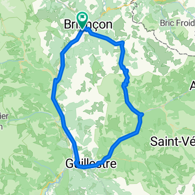
Leave Briançon heading towards Villar-Saint-Pancrace via the D36 known as the road of the Spaniards. The D36 joins the D136 which passes under the N94 after a 150m illuminated tunnel. The D136 then runs alongside the N94 until a roundabout that leads to the D36C allowing to return to the N94 towards Briançon. After crossing the Durance, turn left on the D4 also known as the road of the traverses. Cross the hamlet of Villard Meyer. Continue on the D4 until Vigneaux. Continue on the D4 to the intersection of the D994E. Take the D4 left after 200 m on the D994E at the bridge over the "Gyronde". Continue on the D4 to Puy-St-Vincent. Continue on the D4 to the bridge over the Gyronde. Then take a left on the D994E. The Gyronde becomes the Gyr. Leave the center of Vallouise on the left and go up the Gyr to Ailefroide (1507 m) From Ailefroide, the D994E becomes the D204T as it crosses over the Gyr which becomes the torrent of St Pierre. Follow the D204T which winds along the Torrent to the meadow of Madame Carle.
Balance since Briançon: 39.8 km with an elevation gain of 1210 m.
- -:--
- Duration
- 39.8 km
- Distance
- 1,187 m
- Ascent
- 518 m
- Descent
- ---
- Avg. speed
- ---
- Max. altitude

Route quality
Waytypes & surfaces along the route
Waytypes
Road
11.5 km
(29 %)
Quiet road
0.4 km
(1 %)
Undefined
27.8 km
(70 %)
Surfaces
Paved
25.1 km
(63 %)
Unpaved
0.4 km
(1 %)
Asphalt
25.1 km
(63 %)
Gravel
0.4 km
(1 %)
Undefined
14.3 km
(36 %)
Continue with Bikemap
Use, edit, or download this cycling route
You would like to ride De Briançon au pré de Madame Carle or customize it for your own trip? Here is what you can do with this Bikemap route:
Free features
- Save this route as favorite or in collections
- Copy & plan your own version of this route
- Sync your route with Garmin or Wahoo
Premium features
Free trial for 3 days, or one-time payment. More about Bikemap Premium.
- Navigate this route on iOS & Android
- Export a GPX / KML file of this route
- Create your custom printout (try it for free)
- Download this route for offline navigation
Discover more Premium features.
Get Bikemap PremiumFrom our community
Other popular routes starting in Briançon
 3 Briancon Izoard - Montgenevre - Sestriere -Montgenevre
- Distance
- 101 km
- Ascent
- 2,824 m
- Descent
- 2,787 m
- Location
- Briançon, Provence-Alpes-Côte d'Azur Region, France
 Westalpen Etappe 09 - Briancon
- Distance
- 83.5 km
- Ascent
- 1,633 m
- Descent
- 1,633 m
- Location
- Briançon, Provence-Alpes-Côte d'Azur Region, France
 5-Tag_Briancon-Saluzzo
- Distance
- 125.3 km
- Ascent
- 2,490 m
- Descent
- 3,355 m
- Location
- Briançon, Provence-Alpes-Côte d'Azur Region, France
 Colle dell Izoard
- Distance
- 84.5 km
- Ascent
- 1,581 m
- Descent
- 1,579 m
- Location
- Briançon, Provence-Alpes-Côte d'Azur Region, France
 Col de Granon
- Distance
- 49.5 km
- Ascent
- 1,442 m
- Descent
- 1,442 m
- Location
- Briançon, Provence-Alpes-Côte d'Azur Region, France
![Briançon [Col d'Izoard] loop](https://media.bikemap.net/routes/4330868/staticmaps/in_dc7e89bc-1ec1-4a7f-a59e-af212601d962_400x400_bikemap-2021-3D-static.png) Briançon [Col d'Izoard] loop
Briançon [Col d'Izoard] loop- Distance
- 94.2 km
- Ascent
- 1,814 m
- Descent
- 1,814 m
- Location
- Briançon, Provence-Alpes-Côte d'Azur Region, France
 briancon-izoard
- Distance
- 20.4 km
- Ascent
- 1,201 m
- Descent
- 155 m
- Location
- Briançon, Provence-Alpes-Côte d'Azur Region, France
 p27 Col du Lautaret
- Distance
- 54 km
- Ascent
- 867 m
- Descent
- 1,190 m
- Location
- Briançon, Provence-Alpes-Côte d'Azur Region, France
Open it in the app