
Eifel 3
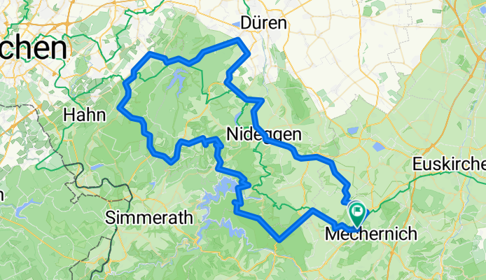
A cycling route starting in Mechernich, North Rhine-Westphalia, Germany.
Overview
About this route
RSG Radz Fatz - Eifel Tag 3 - Vorschlag 1
- -:--
- Duration
- 107.5 km
- Distance
- 1,167 m
- Ascent
- 1,212 m
- Descent
- ---
- Avg. speed
- ---
- Max. altitude

Route quality
Waytypes & surfaces along the route
Waytypes
Road
25.8 km
(24 %)
Quiet road
3.2 km
(3 %)
Surfaces
Paved
87.1 km
(81 %)
Asphalt
86 km
(80 %)
Paved (undefined)
1.1 km
(1 %)
Undefined
20.4 km
(19 %)
Continue with Bikemap
Use, edit, or download this cycling route
You would like to ride Eifel 3 or customize it for your own trip? Here is what you can do with this Bikemap route:
Free features
- Save this route as favorite or in collections
- Copy & plan your own version of this route
- Split it into stages to create a multi-day tour
- Sync your route with Garmin or Wahoo
Premium features
Free trial for 3 days, or one-time payment. More about Bikemap Premium.
- Navigate this route on iOS & Android
- Export a GPX / KML file of this route
- Create your custom printout (try it for free)
- Download this route for offline navigation
Discover more Premium features.
Get Bikemap PremiumFrom our community
Other popular routes starting in Mechernich
 Eifelhöhen 2020
- Distance
- 46.9 km
- Ascent
- 637 m
- Descent
- 632 m
- Location
- Mechernich, North Rhine-Westphalia, Germany
 www.Rad-Rebellen.de - Tour 2
- Distance
- 32.1 km
- Ascent
- 408 m
- Descent
- 410 m
- Location
- Mechernich, North Rhine-Westphalia, Germany
 Runde über Schleiden
- Distance
- 43.6 km
- Ascent
- 585 m
- Descent
- 574 m
- Location
- Mechernich, North Rhine-Westphalia, Germany
 Mechernich- Bad Münstereifel- Wasserscheide- Pesch- Mechernich
- Distance
- 55.6 km
- Ascent
- 722 m
- Descent
- 613 m
- Location
- Mechernich, North Rhine-Westphalia, Germany
 Kommern-Nideggen-Heimbach-Kommern
- Distance
- 53.1 km
- Ascent
- 631 m
- Descent
- 631 m
- Location
- Mechernich, North Rhine-Westphalia, Germany
 EifelSchleife Burg Satzvey (Stadt Mechernich) - EifelSchleife Burg Satzvey (Stadt Mechernich)
- Distance
- 7.3 km
- Ascent
- 105 m
- Descent
- 109 m
- Location
- Mechernich, North Rhine-Westphalia, Germany
 Lessenich - Eschweilerbachtal- Lessenich
- Distance
- 24.5 km
- Ascent
- 244 m
- Descent
- 244 m
- Location
- Mechernich, North Rhine-Westphalia, Germany
 Rundkurs Lessenich-Zingsheim-Lessenich über Römische Straße
- Distance
- 30.9 km
- Ascent
- 439 m
- Descent
- 436 m
- Location
- Mechernich, North Rhine-Westphalia, Germany
Open it in the app