

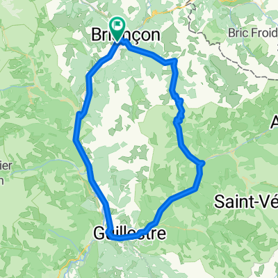
Le col de Granon depuis le "Suite Home" de Briançon
A cycling route starting in Briançon, Provence-Alpes-Côte d'Azur Region, France.
Overview
About this route
Take the Fanton path and head towards avenue du Lautaret. At the roundabout, take avenue de Savoie. At the next roundabout take the road of Pont Levis and cross St Chaffrey. After crossing the torrent of Verdarel (End of St Chaffrey sign), leave the road of Pont-Levis and turn right onto D234 towards Villard Laté and the col de Granon. D234 becomes D234 T. 11 km from the start is the hamlet of Tronchets. The slope steepens after that, with some sections over 10%. The pass is reached after 15.4 km and a height difference of 1140 m.
- -:--
- Duration
- 15.4 km
- Distance
- 1,150 m
- Ascent
- 4 m
- Descent
- ---
- Avg. speed
- ---
- Max. altitude

Route quality
Waytypes & surfaces along the route
Waytypes
Road
11.3 km
(73 %)
Quiet road
0.3 km
(2 %)
Surfaces
Paved
1.8 km
(12 %)
Asphalt
1.8 km
(12 %)
Undefined
13.6 km
(88 %)
Continue with Bikemap
Use, edit, or download this cycling route
You would like to ride Le col de Granon depuis le "Suite Home" de Briançon or customize it for your own trip? Here is what you can do with this Bikemap route:
Free features
- Save this route as favorite or in collections
- Copy & plan your own version of this route
- Sync your route with Garmin or Wahoo
Premium features
Free trial for 3 days, or one-time payment. More about Bikemap Premium.
- Navigate this route on iOS & Android
- Export a GPX / KML file of this route
- Create your custom printout (try it for free)
- Download this route for offline navigation
Discover more Premium features.
Get Bikemap PremiumFrom our community
Other popular routes starting in Briançon
 Col du Galibier via the old road
- Distance
- 52 km
- Ascent
- 1,387 m
- Descent
- 1,239 m
- Location
- Briançon, Provence-Alpes-Côte d'Azur Region, France
 Colle dell Izoard
- Distance
- 84.5 km
- Ascent
- 1,581 m
- Descent
- 1,579 m
- Location
- Briançon, Provence-Alpes-Côte d'Azur Region, France
 Francia_2018_2
- Distance
- 124.1 km
- Ascent
- 2,447 m
- Descent
- 3,033 m
- Location
- Briançon, Provence-Alpes-Côte d'Azur Region, France
 Col du Granon kör
- Distance
- 66.4 km
- Ascent
- 2,625 m
- Descent
- 2,625 m
- Location
- Briançon, Provence-Alpes-Côte d'Azur Region, France
 Col de Granon
- Distance
- 49.5 km
- Ascent
- 1,442 m
- Descent
- 1,442 m
- Location
- Briançon, Provence-Alpes-Côte d'Azur Region, France
 Westalpen Etappe 09 - Briancon
- Distance
- 83.5 km
- Ascent
- 1,633 m
- Descent
- 1,633 m
- Location
- Briançon, Provence-Alpes-Côte d'Azur Region, France
 p27 Col du Lautaret
- Distance
- 54 km
- Ascent
- 867 m
- Descent
- 1,190 m
- Location
- Briançon, Provence-Alpes-Côte d'Azur Region, France
 Col du Granon, Five Gravel Cols, Two Perched Forts
- Distance
- 72.6 km
- Ascent
- 1,887 m
- Descent
- 1,892 m
- Location
- Briançon, Provence-Alpes-Côte d'Azur Region, France
Open it in the app