

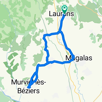
Etappe 01 Fos - Olargues
A cycling route starting in Laurens, Occitanie, France.
Overview
About this route
- -:--
- Duration
- 38.3 km
- Distance
- 424 m
- Ascent
- 544 m
- Descent
- ---
- Avg. speed
- ---
- Max. altitude

Route quality
Waytypes & surfaces along the route
Waytypes
Path
23.1 km
(60 %)
Track
7.7 km
(20 %)
Surfaces
Paved
2.6 km
(7 %)
Unpaved
27.2 km
(71 %)
Gravel
24.3 km
(64 %)
Asphalt
2.4 km
(6 %)
Route highlights
Points of interest along the route
Point of interest after 32.4 km
camping municipal le claps
Point of interest after 33.3 km
camping du caroux
Continue with Bikemap
Use, edit, or download this cycling route
You would like to ride Etappe 01 Fos - Olargues or customize it for your own trip? Here is what you can do with this Bikemap route:
Free features
- Save this route as favorite or in collections
- Copy & plan your own version of this route
- Sync your route with Garmin or Wahoo
Premium features
Free trial for 3 days, or one-time payment. More about Bikemap Premium.
- Navigate this route on iOS & Android
- Export a GPX / KML file of this route
- Create your custom printout (try it for free)
- Download this route for offline navigation
Discover more Premium features.
Get Bikemap PremiumFrom our community
Other popular routes starting in Laurens
 De Place Maurice Sardinoux, Faugères à Place Maurice Sardinoux, Faugères
- Distance
- 0.2 km
- Ascent
- 0 m
- Descent
- 0 m
- Location
- Laurens, Occitanie, France
 Lotissement la Soleiade, Laurens Murviel Les Béziers
- Distance
- 29.3 km
- Ascent
- 272 m
- Descent
- 274 m
- Location
- Laurens, Occitanie, France
 Lotissement la Soleiade, Laurens to Place des Adouzes, Roquessels
- Distance
- 32.7 km
- Ascent
- 677 m
- Descent
- 656 m
- Location
- Laurens, Occitanie, France
 Lotissement la Soleiade, Cessenon sur Orb
- Distance
- 43.6 km
- Ascent
- 575 m
- Descent
- 576 m
- Location
- Laurens, Occitanie, France
 Aufwärmrunde
- Distance
- 26.9 km
- Ascent
- 454 m
- Descent
- 456 m
- Location
- Laurens, Occitanie, France
 Etappe 01 Fos - Olargues
- Distance
- 38.3 km
- Ascent
- 424 m
- Descent
- 544 m
- Location
- Laurens, Occitanie, France
 Boucle faugeres route des vignobles
- Distance
- 25.8 km
- Ascent
- 347 m
- Descent
- 347 m
- Location
- Laurens, Occitanie, France
 Lotissement la Soleiade, Laurens to Rue du Château, Laurens
- Distance
- 29.6 km
- Ascent
- 343 m
- Descent
- 354 m
- Location
- Laurens, Occitanie, France
Open it in the app