

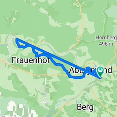
Ausfahrt durch Aalen
A cycling route starting in Abtsgmuend, Baden-Wurttemberg, Germany.
Overview
About this route
- -:--
- Duration
- 14.7 km
- Distance
- 297 m
- Ascent
- 275 m
- Descent
- ---
- Avg. speed
- ---
- Max. altitude

Route quality
Waytypes & surfaces along the route
Waytypes
Quiet road
5.3 km
(36 %)
Road
2.9 km
(20 %)
Surfaces
Paved
11 km
(75 %)
Asphalt
10.6 km
(72 %)
Paved (undefined)
0.4 km
(3 %)
Undefined
3.7 km
(25 %)
Route highlights
Points of interest along the route
Point of interest after 14.6 km
Point of interest after 14.7 km
Point of interest after 14.7 km
Continue with Bikemap
Use, edit, or download this cycling route
You would like to ride Ausfahrt durch Aalen or customize it for your own trip? Here is what you can do with this Bikemap route:
Free features
- Save this route as favorite or in collections
- Copy & plan your own version of this route
- Sync your route with Garmin or Wahoo
Premium features
Free trial for 3 days, or one-time payment. More about Bikemap Premium.
- Navigate this route on iOS & Android
- Export a GPX / KML file of this route
- Create your custom printout (try it for free)
- Download this route for offline navigation
Discover more Premium features.
Get Bikemap PremiumFrom our community
Other popular routes starting in Abtsgmuend
 Kurz nach Hüttlingen
- Distance
- 6.6 km
- Ascent
- 134 m
- Descent
- 146 m
- Location
- Abtsgmuend, Baden-Wurttemberg, Germany
 F-Feld-Aalen-Unterkochen-Essingen-F-feld
- Distance
- 86 km
- Ascent
- 884 m
- Descent
- 883 m
- Location
- Abtsgmuend, Baden-Wurttemberg, Germany
 Abts. Gögg. Hohen. Wölls
- Distance
- 30.9 km
- Ascent
- 314 m
- Descent
- 314 m
- Location
- Abtsgmuend, Baden-Wurttemberg, Germany
 Tour de Ländle (Teilstrecke)
- Distance
- 77.2 km
- Ascent
- 829 m
- Descent
- 869 m
- Location
- Abtsgmuend, Baden-Wurttemberg, Germany
 Ausfahrt durch Aalen
- Distance
- 14.7 km
- Ascent
- 297 m
- Descent
- 275 m
- Location
- Abtsgmuend, Baden-Wurttemberg, Germany
 Skulpturenweg und Rottal CLONED FROM ROUTE 170707
- Distance
- 28.7 km
- Ascent
- 299 m
- Descent
- 299 m
- Location
- Abtsgmuend, Baden-Wurttemberg, Germany
 Laubbach-Stausee nach Laubbach-Stausee
- Distance
- 12.5 km
- Ascent
- 164 m
- Descent
- 193 m
- Location
- Abtsgmuend, Baden-Wurttemberg, Germany
 TSG Saisonabschluss Radtour zum Grillplatz
- Distance
- 18.2 km
- Ascent
- 336 m
- Descent
- 289 m
- Location
- Abtsgmuend, Baden-Wurttemberg, Germany
Open it in the app