

Way of St. James - Le Puy to SJPP
Day 2 - Way of St. James - Le Puy to SJPP
A cycling route starting in Saugues, Auvergne-Rhône-Alpes, France.
Overview
About this route
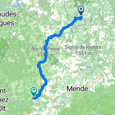
Saugues to Aumont-Aubrac
- -:--
- Duration
- 45.5 km
- Distance
- 775 m
- Ascent
- 699 m
- Descent
- ---
- Avg. speed
- ---
- Max. altitude

Part of
Way of St. James - Le Puy to SJPP
12 stages
Route quality
Waytypes & surfaces along the route
Waytypes
Busy road
31.2 km
(68 %)
Road
6.8 km
(15 %)
Surfaces
Paved
32.8 km
(72 %)
Unpaved
1.7 km
(4 %)
Asphalt
32.8 km
(72 %)
Gravel
1.7 km
(4 %)
Undefined
11 km
(24 %)
Continue with Bikemap
Use, edit, or download this cycling route
You would like to ride Day 2 - Way of St. James - Le Puy to SJPP or customize it for your own trip? Here is what you can do with this Bikemap route:
Free features
- Save this route as favorite or in collections
- Copy & plan your own version of this route
- Sync your route with Garmin or Wahoo
Premium features
Free trial for 3 days, or one-time payment. More about Bikemap Premium.
- Navigate this route on iOS & Android
- Export a GPX / KML file of this route
- Create your custom printout (try it for free)
- Download this route for offline navigation
Discover more Premium features.
Get Bikemap PremiumFrom our community
Other popular routes starting in Saugues
 Thoras - Le Moulin d'Olt (Jakobsweg)
- Distance
- 78 km
- Ascent
- 1,588 m
- Descent
- 2,215 m
- Location
- Saugues, Auvergne-Rhône-Alpes, France
 St Préjet d'Allier, Fridefont
- Distance
- 84.1 km
- Ascent
- 1,181 m
- Descent
- 1,108 m
- Location
- Saugues, Auvergne-Rhône-Alpes, France
 Day 2 - Way of St. James - Le Puy to SJPP
- Distance
- 45.5 km
- Ascent
- 775 m
- Descent
- 699 m
- Location
- Saugues, Auvergne-Rhône-Alpes, France
 LePuy-Pamplona Etappe 02 Saugues Nasbinals
- Distance
- 68.4 km
- Ascent
- 916 m
- Descent
- 706 m
- Location
- Saugues, Auvergne-Rhône-Alpes, France
 2-Saugues vers Aumont Aubrac
- Distance
- 55.7 km
- Ascent
- 1,008 m
- Descent
- 935 m
- Location
- Saugues, Auvergne-Rhône-Alpes, France
 66k Saugues
- Distance
- 68.2 km
- Ascent
- 1,064 m
- Descent
- 1,011 m
- Location
- Saugues, Auvergne-Rhône-Alpes, France
 etape1
- Distance
- 76.6 km
- Ascent
- 1,289 m
- Descent
- 1,215 m
- Location
- Saugues, Auvergne-Rhône-Alpes, France
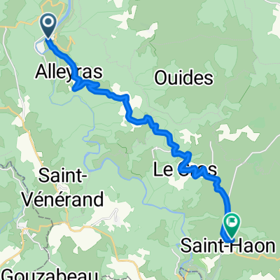 Et. 6 Alleyras / Saint-Haon
- Distance
- 16 km
- Ascent
- 820 m
- Descent
- 481 m
- Location
- Saugues, Auvergne-Rhône-Alpes, France
Open it in the app