

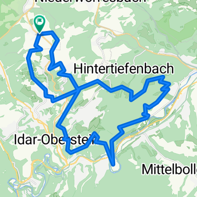
Idar Oberstein 14
A cycling route starting in Veitsrodt, Rhineland-Palatinate, Germany.
Overview
About this route
- -:--
- Duration
- 113 km
- Distance
- 1,012 m
- Ascent
- 1,012 m
- Descent
- ---
- Avg. speed
- ---
- Max. altitude

Continue with Bikemap
Use, edit, or download this cycling route
You would like to ride Idar Oberstein 14 or customize it for your own trip? Here is what you can do with this Bikemap route:
Free features
- Save this route as favorite or in collections
- Copy & plan your own version of this route
- Split it into stages to create a multi-day tour
- Sync your route with Garmin or Wahoo
Premium features
Free trial for 3 days, or one-time payment. More about Bikemap Premium.
- Navigate this route on iOS & Android
- Export a GPX / KML file of this route
- Create your custom printout (try it for free)
- Download this route for offline navigation
Discover more Premium features.
Get Bikemap PremiumFrom our community
Other popular routes starting in Veitsrodt
 Idar-Oberstein-1A-64KM
- Distance
- 64.8 km
- Ascent
- 853 m
- Descent
- 853 m
- Location
- Veitsrodt, Rhineland-Palatinate, Germany
 Idar-Oberstein 6C 85KM
- Distance
- 85.4 km
- Ascent
- 1,163 m
- Descent
- 1,067 m
- Location
- Veitsrodt, Rhineland-Palatinate, Germany
 Idar Oberstein 14
- Distance
- 113 km
- Ascent
- 1,012 m
- Descent
- 1,012 m
- Location
- Veitsrodt, Rhineland-Palatinate, Germany
 Idar-Oberstein-1A-64KM
- Distance
- 64.7 km
- Ascent
- 1,425 m
- Descent
- 1,292 m
- Location
- Veitsrodt, Rhineland-Palatinate, Germany
 Road Erweskopp iwa Leisel
- Distance
- 20.6 km
- Ascent
- 586 m
- Descent
- 587 m
- Location
- Veitsrodt, Rhineland-Palatinate, Germany
 Road Feierabend Nord-32
- Distance
- 32 km
- Ascent
- 579 m
- Descent
- 602 m
- Location
- Veitsrodt, Rhineland-Palatinate, Germany
 Road - Uwastään - Felsenpfad - Reelser Haid - Road
- Distance
- 32.8 km
- Ascent
- 889 m
- Descent
- 888 m
- Location
- Veitsrodt, Rhineland-Palatinate, Germany
 Road - Nahe-Skywalk
- Distance
- 46.2 km
- Ascent
- 873 m
- Descent
- 872 m
- Location
- Veitsrodt, Rhineland-Palatinate, Germany
Open it in the app