

13. Frankenberger Radlersonntag 2017 - 100 km Strecke (neu)
A cycling route starting in Frankenberg, Saxony, Germany.
Overview
About this route
Streckenbeschreibung:
Diese Runde für gut trainierte Fahrer über 103 km (Rennrad empfohlen) wird am 21. Mai 2017 beim 13. Frankenberger Radlersonntag gefahren, Start und Ziel auf der Jahnkampfbahn, Meltzerstraße, Frankenberg/Sa.
Die hügelige, landschaftlich abwechslungsreiche Tour kreuzt die Flusstäler der Chemnitz und der Zschopau und führt hauptsächlich über verkehrsarme Nebenstraßen, aber auch ein kurzes Teilstück des Chemnitztal-Radweges ist enthalten.
Streckenverlauf:
Frankenberg – Kreisverkehr – über Kirschberg nach Lichtenwalde – Ebersdorf – über Stiftsweg nach Chemnitz-Glösa – Chemnitztalstraße (B107) stadteinwärts, dann auf Bornaer Straße – nahe Kreisverkehr auf Chemnitztalradweg – Wittgensdorf – Hartmannsdorf – über Bahnhofstraße nach Limbach-Oberfrohna – Niederfrohna - Mühlau – Burgstädt - Herrenhaide – Taura – Claußnitz (Verpflegungspunkt am SIMMEL-Markt) – Altmittweida – Mittweida – Weinsdorf – Rossau – Höckendorf – Grünlichtenberg – Reichenbach – Greifendorf – Moosheim – Rossau – Hainichen (durchs Gewerbegebiet auf Radweg Richtung Stadtmitte) – Berthelsdorf – Dittersbach - Frankenberg
- -:--
- Duration
- 103 km
- Distance
- 582 m
- Ascent
- 582 m
- Descent
- ---
- Avg. speed
- ---
- Max. altitude

Route quality
Waytypes & surfaces along the route
Waytypes
Quiet road
36.8 km
(36 %)
Road
31.1 km
(30 %)
Surfaces
Paved
79.8 km
(77 %)
Unpaved
0.9 km
(<1 %)
Asphalt
73.7 km
(72 %)
Paving stones
3.8 km
(4 %)
Continue with Bikemap
Use, edit, or download this cycling route
You would like to ride 13. Frankenberger Radlersonntag 2017 - 100 km Strecke (neu) or customize it for your own trip? Here is what you can do with this Bikemap route:
Free features
- Save this route as favorite or in collections
- Copy & plan your own version of this route
- Split it into stages to create a multi-day tour
- Sync your route with Garmin or Wahoo
Premium features
Free trial for 3 days, or one-time payment. More about Bikemap Premium.
- Navigate this route on iOS & Android
- Export a GPX / KML file of this route
- Create your custom printout (try it for free)
- Download this route for offline navigation
Discover more Premium features.
Get Bikemap PremiumFrom our community
Other popular routes starting in Frankenberg
 Am Mühlberg, Frankenberg/Sachsen nach Marienberger Straße, Großrückerswalde
- Distance
- 45.2 km
- Ascent
- 1,014 m
- Descent
- 688 m
- Location
- Frankenberg, Saxony, Germany
 Runde von Mühlbach nach Kriebstein und zurück
- Distance
- 52.8 km
- Ascent
- 698 m
- Descent
- 701 m
- Location
- Frankenberg, Saxony, Germany
 Männertagsrunde 2019
- Distance
- 77.8 km
- Ascent
- 607 m
- Descent
- 608 m
- Location
- Frankenberg, Saxony, Germany
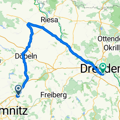 Frankenberg - Riesa - Dresden
- Distance
- 104.3 km
- Ascent
- 338 m
- Descent
- 511 m
- Location
- Frankenberg, Saxony, Germany
 Hetzdorfer Viadukt über Ranis
- Distance
- 53.6 km
- Ascent
- 728 m
- Descent
- 726 m
- Location
- Frankenberg, Saxony, Germany
 von Frankenberg nach Flöha - von Frankenberg nach Flöha
- Distance
- 12.9 km
- Ascent
- 362 m
- Descent
- 364 m
- Location
- Frankenberg, Saxony, Germany
 6.2.2.Rundweg Lützeltal-Buchenwald-grün
- Distance
- 10.5 km
- Ascent
- 115 m
- Descent
- 114 m
- Location
- Frankenberg, Saxony, Germany
 Hainichen
- Distance
- 28.2 km
- Ascent
- 331 m
- Descent
- 334 m
- Location
- Frankenberg, Saxony, Germany
Open it in the app