
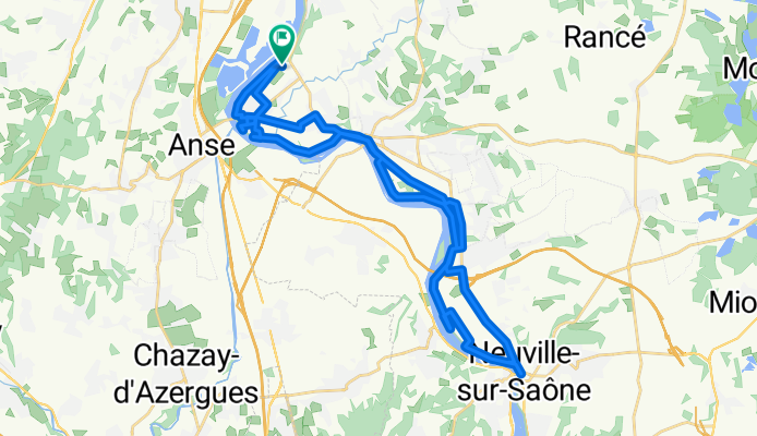
Bords de Saône
A cycling route starting in Trévoux, Auvergne-Rhône-Alpes, France.
Overview
About this route
St Bernard - Neuville.
By towpath.
Recovery route.
- -:--
- Duration
- 37.1 km
- Distance
- 105 m
- Ascent
- 102 m
- Descent
- ---
- Avg. speed
- 188 m
- Max. altitude
Route quality
Waytypes & surfaces along the route
Waytypes
Quiet road
11.9 km
(32 %)
Path
7.8 km
(21 %)
Surfaces
Paved
15.2 km
(41 %)
Unpaved
8.9 km
(24 %)
Asphalt
12.6 km
(34 %)
Gravel
6.7 km
(18 %)
Continue with Bikemap
Use, edit, or download this cycling route
You would like to ride Bords de Saône or customize it for your own trip? Here is what you can do with this Bikemap route:
Free features
- Save this route as favorite or in collections
- Copy & plan your own version of this route
- Sync your route with Garmin or Wahoo
Premium features
Free trial for 3 days, or one-time payment. More about Bikemap Premium.
- Navigate this route on iOS & Android
- Export a GPX / KML file of this route
- Create your custom printout (try it for free)
- Download this route for offline navigation
Discover more Premium features.
Get Bikemap PremiumFrom our community
Other popular routes starting in Trévoux
 Route du Soleil: dag 12
- Distance
- 89 km
- Ascent
- 175 m
- Descent
- 206 m
- Location
- Trévoux, Auvergne-Rhône-Alpes, France
 Trévoux nach Avenue de la Plage 37, Villefranche-sur-Saône
- Distance
- 9.8 km
- Ascent
- 8 m
- Descent
- 8 m
- Location
- Trévoux, Auvergne-Rhône-Alpes, France
 Tag 12. 87 Rue de la Montluelde, Trévoux nach 339 Route du Bessay, Estrablin
- Distance
- 68.5 km
- Ascent
- 139 m
- Descent
- 135 m
- Location
- Trévoux, Auvergne-Rhône-Alpes, France
 Bords de Saône
- Distance
- 37.1 km
- Ascent
- 105 m
- Descent
- 102 m
- Location
- Trévoux, Auvergne-Rhône-Alpes, France
 2014_E9_Trévoux-Givors
- Distance
- 50.7 km
- Ascent
- 229 m
- Descent
- 239 m
- Location
- Trévoux, Auvergne-Rhône-Alpes, France
 VTT - St Bernard - Monts d'Or : Essai 1
- Distance
- 50.4 km
- Ascent
- 801 m
- Descent
- 804 m
- Location
- Trévoux, Auvergne-Rhône-Alpes, France
 Rue Brûlée to Route de Simandre
- Distance
- 90.6 km
- Ascent
- 238 m
- Descent
- 188 m
- Location
- Trévoux, Auvergne-Rhône-Alpes, France
 14) Trévoux - St Genis Laval
- Distance
- 38.4 km
- Ascent
- 229 m
- Descent
- 130 m
- Location
- Trévoux, Auvergne-Rhône-Alpes, France
Open it in the app