

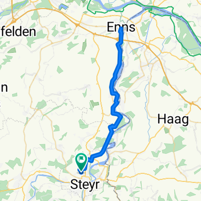
Steyr - Schoberstein
A cycling route starting in Steyr, Upper Austria, Austria.
Overview
About this route
- -:--
- Duration
- 28.6 km
- Distance
- 1,010 m
- Ascent
- 349 m
- Descent
- ---
- Avg. speed
- 957 m
- Max. altitude

Route quality
Waytypes & surfaces along the route
Waytypes
Road
10.9 km
(38 %)
Track
9.7 km
(34 %)
Surfaces
Paved
11.7 km
(41 %)
Unpaved
9.7 km
(34 %)
Asphalt
11.7 km
(41 %)
Gravel
9.7 km
(34 %)
Undefined
7.1 km
(25 %)
Continue with Bikemap
Use, edit, or download this cycling route
You would like to ride Steyr - Schoberstein or customize it for your own trip? Here is what you can do with this Bikemap route:
Free features
- Save this route as favorite or in collections
- Copy & plan your own version of this route
- Sync your route with Garmin or Wahoo
Premium features
Free trial for 3 days, or one-time payment. More about Bikemap Premium.
- Navigate this route on iOS & Android
- Export a GPX / KML file of this route
- Create your custom printout (try it for free)
- Download this route for offline navigation
Discover more Premium features.
Get Bikemap PremiumFrom our community
Other popular routes starting in Steyr
 SR - Steinbach/Steyr - GrüHü - Schoberstein - Trattenbach - SR
- Distance
- 68.3 km
- Ascent
- 1,196 m
- Descent
- 1,196 m
- Location
- Steyr, Upper Austria, Austria
 Steyr - Schoberstein
- Distance
- 28.6 km
- Ascent
- 1,010 m
- Descent
- 349 m
- Location
- Steyr, Upper Austria, Austria
 Spadenberg Special
- Distance
- 46 km
- Ascent
- 1,031 m
- Descent
- 1,027 m
- Location
- Steyr, Upper Austria, Austria
 Ennsrunde Variante
- Distance
- 41.9 km
- Ascent
- 234 m
- Descent
- 235 m
- Location
- Steyr, Upper Austria, Austria
 Steyr - OÖ Enns mit Mündung - NÖ - Steyr
- Distance
- 73.8 km
- Ascent
- 522 m
- Descent
- 522 m
- Location
- Steyr, Upper Austria, Austria
 Steyr day 1
- Distance
- 14.6 km
- Ascent
- 268 m
- Descent
- 269 m
- Location
- Steyr, Upper Austria, Austria
 Steyrtalrunde
- Distance
- 27 km
- Ascent
- 434 m
- Descent
- 433 m
- Location
- Steyr, Upper Austria, Austria
 Joseph-Löw-Straße, Steyr nach Joseph-Löw-Straße, Steyr
- Distance
- 48.9 km
- Ascent
- 439 m
- Descent
- 437 m
- Location
- Steyr, Upper Austria, Austria
Open it in the app