
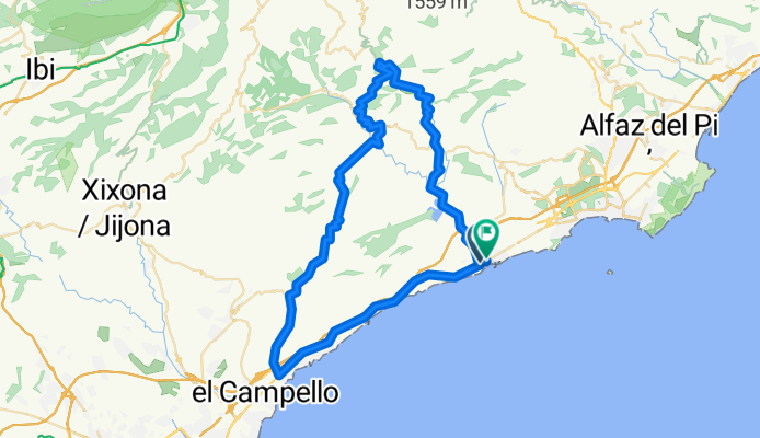
Campello - Aigües - Rapelles - La Vila
A cycling route starting in Villajoyosa, Valencia, Spain.
Overview
About this route
La Vila - Campello - Aigües - Relleu - Rapelles - La Vila
- -:--
- Duration
- 73.8 km
- Distance
- 1,456 m
- Ascent
- 1,058 m
- Descent
- ---
- Avg. speed
- 505 m
- Max. altitude

Route quality
Waytypes & surfaces along the route
Waytypes
Busy road
46.6 km
(63 %)
Cycleway
9.7 km
(13 %)
Surfaces
Paved
25.6 km
(35 %)
Unpaved
3.6 km
(5 %)
Asphalt
25.1 km
(34 %)
Gravel
2 km
(3 %)
Continue with Bikemap
Use, edit, or download this cycling route
You would like to ride Campello - Aigües - Rapelles - La Vila or customize it for your own trip? Here is what you can do with this Bikemap route:
Free features
- Save this route as favorite or in collections
- Copy & plan your own version of this route
- Sync your route with Garmin or Wahoo
Premium features
Free trial for 3 days, or one-time payment. More about Bikemap Premium.
- Navigate this route on iOS & Android
- Export a GPX / KML file of this route
- Create your custom printout (try it for free)
- Download this route for offline navigation
Discover more Premium features.
Get Bikemap PremiumFrom our community
Other popular routes starting in Villajoyosa
 Campello - Aigües - Rapelles - La Vila
- Distance
- 73.8 km
- Ascent
- 1,456 m
- Descent
- 1,058 m
- Location
- Villajoyosa, Valencia, Spain
 villajoyossa_alicante.gpx
- Distance
- 35.9 km
- Ascent
- 305 m
- Descent
- 316 m
- Location
- Villajoyosa, Valencia, Spain
 RUTA TRIATLO LA VILA 02/04/2011
- Distance
- 114.5 km
- Ascent
- 1,314 m
- Descent
- 1,312 m
- Location
- Villajoyosa, Valencia, Spain
 Tarbena - Castell de Castells - Benissa - La Vila
- Distance
- 115.4 km
- Ascent
- 1,153 m
- Descent
- 1,157 m
- Location
- Villajoyosa, Valencia, Spain
 Finestrat Åse 190920
- Distance
- 42.3 km
- Ascent
- 832 m
- Descent
- 825 m
- Location
- Villajoyosa, Valencia, Spain
 Embalse de Amadono - Relleu
- Distance
- 40.7 km
- Ascent
- 572 m
- Descent
- 572 m
- Location
- Villajoyosa, Valencia, Spain
 Mar y montaña
- Distance
- 70.7 km
- Ascent
- 1,407 m
- Descent
- 1,404 m
- Location
- Villajoyosa, Valencia, Spain
 La Vila - La Torre - Carrasqueta - Penaguila - La Vila
- Distance
- 113.9 km
- Ascent
- 1,804 m
- Descent
- 1,808 m
- Location
- Villajoyosa, Valencia, Spain
Open it in the app