

Rot - Maikammer über Germersheim
A cycling route starting in Kronau, Baden-Wurttemberg, Germany.
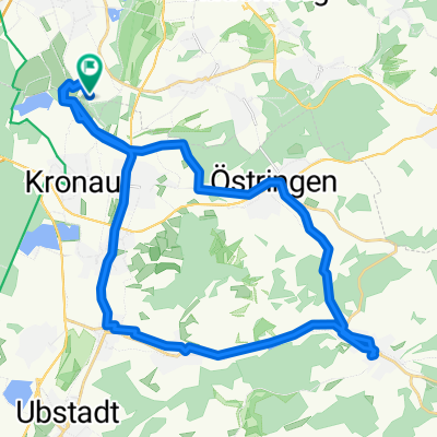
Overview
About this route
Variante über Germereim, befestigt, Ortschaften und Straßen vermeidend
- -:--
- Duration
- 53.2 km
- Distance
- 106 m
- Ascent
- 43 m
- Descent
- ---
- Avg. speed
- ---
- Max. altitude
Route quality
Waytypes & surfaces along the route
Waytypes
Track
21.9 km
(41 %)
Path
10.5 km
(20 %)
Surfaces
Paved
45.3 km
(85 %)
Unpaved
0.6 km
(1 %)
Asphalt
36.2 km
(68 %)
Paved (undefined)
8.1 km
(15 %)
Continue with Bikemap
Use, edit, or download this cycling route
You would like to ride Rot - Maikammer über Germersheim or customize it for your own trip? Here is what you can do with this Bikemap route:
Free features
- Save this route as favorite or in collections
- Copy & plan your own version of this route
- Sync your route with Garmin or Wahoo
Premium features
Free trial for 3 days, or one-time payment. More about Bikemap Premium.
- Navigate this route on iOS & Android
- Export a GPX / KML file of this route
- Create your custom printout (try it for free)
- Download this route for offline navigation
Discover more Premium features.
Get Bikemap PremiumFrom our community
Other popular routes starting in Kronau
 SAP Rot nach Wiesloch über Gänsberg
- Distance
- 9.3 km
- Ascent
- 79 m
- Descent
- 58 m
- Location
- Kronau, Baden-Wurttemberg, Germany
 Bad Langenbrücken
- Distance
- 74.2 km
- Ascent
- 236 m
- Descent
- 237 m
- Location
- Kronau, Baden-Wurttemberg, Germany
 BW-Rundfahrt
- Distance
- 801 km
- Ascent
- 1,081 m
- Descent
- 1,082 m
- Location
- Kronau, Baden-Wurttemberg, Germany
 St. Leon-Rot - Zuzenhausen
- Distance
- 21 km
- Ascent
- 180 m
- Descent
- 149 m
- Location
- Kronau, Baden-Wurttemberg, Germany
 HD-Kirchheim <-> St. Leon-Rot, SAP
- Distance
- 18.1 km
- Ascent
- 36 m
- Descent
- 37 m
- Location
- Kronau, Baden-Wurttemberg, Germany
 Kleine SAP ITS Kraichgaurunde
- Distance
- 33.4 km
- Ascent
- 198 m
- Descent
- 201 m
- Location
- Kronau, Baden-Wurttemberg, Germany
 SAP Rot - HD - Whm
- Distance
- 39.7 km
- Ascent
- 147 m
- Descent
- 122 m
- Location
- Kronau, Baden-Wurttemberg, Germany
 Welterbe-Tour
- Distance
- 77.8 km
- Ascent
- 512 m
- Descent
- 400 m
- Location
- Kronau, Baden-Wurttemberg, Germany
Open it in the app