

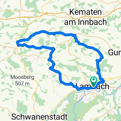
Lambach-Molln
A cycling route starting in Lambach, Upper Austria, Austria.
Overview
About this route
May 19, 2017
- -:--
- Duration
- 65.4 km
- Distance
- 479 m
- Ascent
- 384 m
- Descent
- ---
- Avg. speed
- ---
- Max. altitude

Route quality
Waytypes & surfaces along the route
Waytypes
Quiet road
43.1 km
(66 %)
Cycleway
7.8 km
(12 %)
Surfaces
Paved
25.5 km
(39 %)
Unpaved
3.3 km
(5 %)
Asphalt
20.3 km
(31 %)
Paved (undefined)
5.2 km
(8 %)
Continue with Bikemap
Use, edit, or download this cycling route
You would like to ride Lambach-Molln or customize it for your own trip? Here is what you can do with this Bikemap route:
Free features
- Save this route as favorite or in collections
- Copy & plan your own version of this route
- Sync your route with Garmin or Wahoo
Premium features
Free trial for 3 days, or one-time payment. More about Bikemap Premium.
- Navigate this route on iOS & Android
- Export a GPX / KML file of this route
- Create your custom printout (try it for free)
- Download this route for offline navigation
Discover more Premium features.
Get Bikemap PremiumFrom our community
Other popular routes starting in Lambach
 kemal 1
- Distance
- 26.4 km
- Ascent
- 25 m
- Descent
- 95 m
- Location
- Lambach, Upper Austria, Austria
 Lambach - Aschau im Chiemgau
- Distance
- 162.8 km
- Ascent
- 760 m
- Descent
- 520 m
- Location
- Lambach, Upper Austria, Austria
 Gmunden
- Distance
- 28.1 km
- Ascent
- 304 m
- Descent
- 253 m
- Location
- Lambach, Upper Austria, Austria
 Lambach-Pfarrgasse Haager Lies
- Distance
- 64.8 km
- Ascent
- 463 m
- Descent
- 514 m
- Location
- Lambach, Upper Austria, Austria
 Lambach Bad Gams
- Distance
- 257.4 km
- Ascent
- 2,422 m
- Descent
- 2,415 m
- Location
- Lambach, Upper Austria, Austria
 Lambachrunde
- Distance
- 38.4 km
- Ascent
- 398 m
- Descent
- 401 m
- Location
- Lambach, Upper Austria, Austria
 Teilstück von R4 OÖ
- Distance
- 50.6 km
- Ascent
- 605 m
- Descent
- 588 m
- Location
- Lambach, Upper Austria, Austria
 Hausruck, Kobernauserrunde
- Distance
- 131.1 km
- Ascent
- 1,220 m
- Descent
- 1,220 m
- Location
- Lambach, Upper Austria, Austria
Open it in the app