
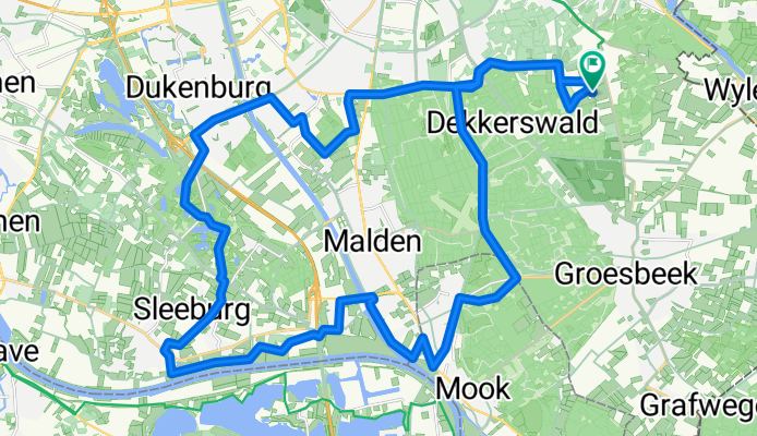
Berg En Dal
A cycling route starting in Berg en Dal, Gelderland, The Netherlands.
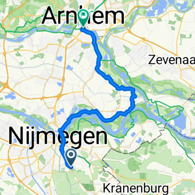
Overview
About this route
- -:--
- Duration
- 38 km
- Distance
- 142 m
- Ascent
- 143 m
- Descent
- ---
- Avg. speed
- ---
- Max. altitude
Route quality
Waytypes & surfaces along the route
Waytypes
Cycleway
15.6 km
(41 %)
Quiet road
9.9 km
(26 %)
Surfaces
Paved
30.8 km
(81 %)
Unpaved
2.7 km
(7 %)
Asphalt
27.4 km
(72 %)
Concrete
3.4 km
(9 %)
Route highlights
Points of interest along the route

Photo after 8.5 km

Photo after 11.6 km

Photo after 12.9 km

Photo after 19 km

Photo after 19 km

Photo after 22.9 km

Photo after 34.3 km

Photo after 34.3 km
Continue with Bikemap
Use, edit, or download this cycling route
You would like to ride Berg En Dal or customize it for your own trip? Here is what you can do with this Bikemap route:
Free features
- Save this route as favorite or in collections
- Copy & plan your own version of this route
- Sync your route with Garmin or Wahoo
Premium features
Free trial for 3 days, or one-time payment. More about Bikemap Premium.
- Navigate this route on iOS & Android
- Export a GPX / KML file of this route
- Create your custom printout (try it for free)
- Download this route for offline navigation
Discover more Premium features.
Get Bikemap PremiumFrom our community
Other popular routes starting in Berg en Dal
 Polder to Beekhuizenseweg
- Distance
- 30.7 km
- Ascent
- 161 m
- Descent
- 85 m
- Location
- Berg en Dal, Gelderland, The Netherlands
 20160424 Fietsclinic Club Actief Spinners Alpe d'Huez
- Distance
- 37 km
- Ascent
- 364 m
- Descent
- 364 m
- Location
- Berg en Dal, Gelderland, The Netherlands
 Rees - Haltern
- Distance
- 87.4 km
- Ascent
- 308 m
- Descent
- 360 m
- Location
- Berg en Dal, Gelderland, The Netherlands
 Berg en Dal, Duivelsberg, Wylermeer
- Distance
- 10.9 km
- Ascent
- 142 m
- Descent
- 140 m
- Location
- Berg en Dal, Gelderland, The Netherlands
 Ronde Rijk van Nijmegen
- Distance
- 76.7 km
- Ascent
- 424 m
- Descent
- 421 m
- Location
- Berg en Dal, Gelderland, The Netherlands
 nijmegen
- Distance
- 47 km
- Ascent
- 346 m
- Descent
- 348 m
- Location
- Berg en Dal, Gelderland, The Netherlands
 Polder to Heijendaalseweg, Vorden
- Distance
- 49.3 km
- Ascent
- 62 m
- Descent
- 52 m
- Location
- Berg en Dal, Gelderland, The Netherlands
 Venerdì Heilig Landstichting - Arnhem
- Distance
- 33.9 km
- Ascent
- 16 m
- Descent
- 72 m
- Location
- Berg en Dal, Gelderland, The Netherlands
Open it in the app