

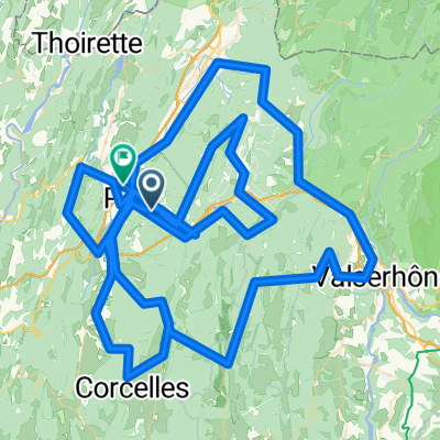
Jura Col Hunting via Trails
A cycling route starting in Nantua, Auvergne-Rhône-Alpes, France.
Overview
About this route
- -:--
- Duration
- 63 km
- Distance
- 1,280 m
- Ascent
- 1,280 m
- Descent
- ---
- Avg. speed
- ---
- Max. altitude

Route quality
Waytypes & surfaces along the route
Waytypes
Track
21.4 km
(34 %)
Road
15.8 km
(25 %)
Surfaces
Paved
2.5 km
(4 %)
Unpaved
7.6 km
(12 %)
Unpaved (undefined)
3.8 km
(6 %)
Gravel
3.2 km
(5 %)
Route highlights
Points of interest along the route
Point of interest after 9.2 km
Les Monts d'Ain - 988m
Point of interest after 12.5 km
Golet du Brêt - 970m
Point of interest after 30.9 km
Air crash monument
Point of interest after 31.9 km
Borne des Trois Cantons - 1163 metres
Point of interest after 33.7 km
Col de la Croix d'Orms - 1099m
Point of interest after 35 km
Col de Valorse - 1079m
Point of interest after 47.5 km
Col de la Cheminée - 925m
Point of interest after 49.1 km
Golet Géla - 937m
Point of interest after 53.6 km
Col de la Belleroche - 1056m
Point of interest after 56.1 km
Col de Colliard - 979m
Continue with Bikemap
Use, edit, or download this cycling route
You would like to ride Jura Col Hunting via Trails or customize it for your own trip? Here is what you can do with this Bikemap route:
Free features
- Save this route as favorite or in collections
- Copy & plan your own version of this route
- Sync your route with Garmin or Wahoo
Premium features
Free trial for 3 days, or one-time payment. More about Bikemap Premium.
- Navigate this route on iOS & Android
- Export a GPX / KML file of this route
- Create your custom printout (try it for free)
- Download this route for offline navigation
Discover more Premium features.
Get Bikemap PremiumFrom our community
Other popular routes starting in Nantua
 Nantua - Monts de l'Ain
- Distance
- 89.8 km
- Ascent
- 1,567 m
- Descent
- 1,568 m
- Location
- Nantua, Auvergne-Rhône-Alpes, France
 De 311 Rue de la Gélinotte, Nantua à 297 Rue de la Gélinotte, Nantua
- Distance
- 15.3 km
- Ascent
- 57 m
- Descent
- 52 m
- Location
- Nantua, Auvergne-Rhône-Alpes, France
 NANTUA - CHAMBÉRY
- Distance
- 181.3 km
- Ascent
- 4,063 m
- Descent
- 4,285 m
- Location
- Nantua, Auvergne-Rhône-Alpes, France
 GF NANTUA
- Distance
- 212.2 km
- Ascent
- 2,515 m
- Descent
- 2,518 m
- Location
- Nantua, Auvergne-Rhône-Alpes, France
 Golets
- Distance
- 56.6 km
- Ascent
- 1,069 m
- Descent
- 1,072 m
- Location
- Nantua, Auvergne-Rhône-Alpes, France
 Col Hunting Juras
- Distance
- 24.7 km
- Ascent
- 759 m
- Descent
- 100 m
- Location
- Nantua, Auvergne-Rhône-Alpes, France
 2020-06-07 / Haut Bugey - Plateau du Retord
- Distance
- 56.7 km
- Ascent
- 3,182 m
- Descent
- 3,186 m
- Location
- Nantua, Auvergne-Rhône-Alpes, France
 Jura Col Hunting loop
- Distance
- 58.8 km
- Ascent
- 1,116 m
- Descent
- 1,115 m
- Location
- Nantua, Auvergne-Rhône-Alpes, France
Open it in the app