
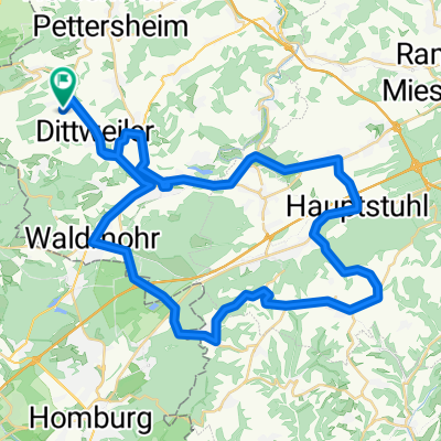
Waldmohr Vogelbach Hauptstuhl Nanzdietschweiler Schülerfahrt
A cycling route starting in Altenkirchen, Rhineland-Palatinate, Germany.
Overview
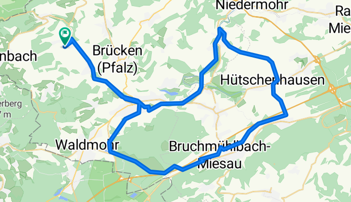
About this route
Tolles Wetter aber strammer Westwind. Volker ist gestürzt und hat ziemliche Armverletzung.
- 2 h 43 min
- Duration
- 46.1 km
- Distance
- 168 m
- Ascent
- 168 m
- Descent
- 16.9 km/h
- Avg. speed
- ---
- Max. altitude
Route quality
Waytypes & surfaces along the route
Waytypes
Path
14.4 km
(31 %)
Track
9.5 km
(21 %)
Surfaces
Paved
36.3 km
(79 %)
Unpaved
6.5 km
(14 %)
Asphalt
29 km
(63 %)
Paved (undefined)
3.9 km
(9 %)
Continue with Bikemap
Use, edit, or download this cycling route
You would like to ride Waldmohr Vogelbach Hauptstuhl Nanzdietschweiler Schülerfahrt or customize it for your own trip? Here is what you can do with this Bikemap route:
Free features
- Save this route as favorite or in collections
- Copy & plan your own version of this route
- Sync your route with Garmin or Wahoo
Premium features
Free trial for 3 days, or one-time payment. More about Bikemap Premium.
- Navigate this route on iOS & Android
- Export a GPX / KML file of this route
- Create your custom printout (try it for free)
- Download this route for offline navigation
Discover more Premium features.
Get Bikemap PremiumFrom our community
Other popular routes starting in Altenkirchen
 Altenglan-Kusel-Werschweiler-Frohnhofen
- Distance
- 65.8 km
- Ascent
- 462 m
- Descent
- 462 m
- Location
- Altenkirchen, Rhineland-Palatinate, Germany
 Waldmohr Vogelbach Hauptstuhl Nanzdietschweiler Schülerfahrt
- Distance
- 46.1 km
- Ascent
- 168 m
- Descent
- 168 m
- Location
- Altenkirchen, Rhineland-Palatinate, Germany
 Bitche Reichshoffen Woerth Hoffen Stundwiller Hatten Beinheim Rastastt Neuburgweiher Karlsruhe
- Distance
- 173.4 km
- Ascent
- 355 m
- Descent
- 544 m
- Location
- Altenkirchen, Rhineland-Palatinate, Germany
 Schmittweiler-Dunzweiler Waldmohr Jägersburg
- Distance
- 33 km
- Ascent
- 329 m
- Descent
- 329 m
- Location
- Altenkirchen, Rhineland-Palatinate, Germany
 Kusel>Altenglan> Ramstein-Miesenbach>Hütschenhausen und Heim CLONED FROM ROUTE 1766172
- Distance
- 64.7 km
- Ascent
- 337 m
- Descent
- 337 m
- Location
- Altenkirchen, Rhineland-Palatinate, Germany
 Rockenhausen die Hinfahrt über Schallodenbach. Retoure über Otterberg
- Distance
- 127.4 km
- Ascent
- 748 m
- Descent
- 749 m
- Location
- Altenkirchen, Rhineland-Palatinate, Germany
 Brücken Hauptstuhl Martinshöhe Lambsborn Waldmohr
- Distance
- 56.2 km
- Ascent
- 466 m
- Descent
- 466 m
- Location
- Altenkirchen, Rhineland-Palatinate, Germany
 Bechhofen Homburg Bexbach Münchwies Führt Werschweiler
- Distance
- 53.3 km
- Ascent
- 486 m
- Descent
- 471 m
- Location
- Altenkirchen, Rhineland-Palatinate, Germany
Open it in the app