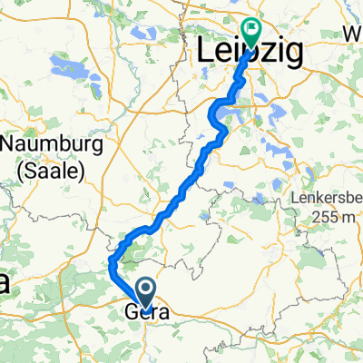
Gera -Reust-Ronneburg -Gera
A cycling route starting in Gera, Free State of Thuringia, Germany.
Overview
About this route
Alt-bieblach-Berliner straße-Zentrum-Reichsstraße-Pforten Zwötzen-Salzstraße-Scherpstraße-Alt-Taubenpreskeln-Poris-Lengefeld-Lichtenberg-Hilbersdorf-Rußdorf-Reust-Ronneburg -Gessental-Collis-Pforten-Stadion am Steg-Debschwitz-Tierpark(martinsgrund)-Spielwiese-Heinrichsbrücke-Hofwiesenpark-Untermhaus-Schafwiesensiedlung-Franzosenbrücke(elsterradweg)-Rieger-Tinz-Alt-Bieblach
- -:--
- Duration
- 44 km
- Distance
- 309 m
- Ascent
- 311 m
- Descent
- ---
- Avg. speed
- ---
- Avg. speed
Route quality
Waytypes & surfaces along the route
Waytypes
Quiet road
10.8 km
(25 %)
Road
7.9 km
(18 %)
Surfaces
Paved
31.8 km
(72 %)
Unpaved
0.7 km
(2 %)
Asphalt
25.8 km
(59 %)
Paved (undefined)
2.7 km
(6 %)
Continue with Bikemap
Use, edit, or download this cycling route
You would like to ride Gera -Reust-Ronneburg -Gera or customize it for your own trip? Here is what you can do with this Bikemap route:
Free features
- Save this route as favorite or in collections
- Copy & plan your own version of this route
- Sync your route with Garmin or Wahoo
Premium features
Free trial for 3 days, or one-time payment. More about Bikemap Premium.
- Navigate this route on iOS & Android
- Export a GPX / KML file of this route
- Create your custom printout (try it for free)
- Download this route for offline navigation
Discover more Premium features.
Get Bikemap PremiumFrom our community
Other popular routes starting in Gera
- Gera Pegau
- Distance
- 46.9 km
- Ascent
- 143 m
- Descent
- 201 m
- Location
- Gera, Free State of Thuringia, Germany
- Crimmitschau - Kap Arkona 2013 R 01/T01/TA02/V01
- Distance
- 29 km
- Ascent
- 171 m
- Descent
- 205 m
- Location
- Gera, Free State of Thuringia, Germany
- Gera-Wünschendorf-Gera 16.3.2015
- Distance
- 35.6 km
- Ascent
- 187 m
- Descent
- 187 m
- Location
- Gera, Free State of Thuringia, Germany
- Tag 5 - 77,8 km
- Distance
- 78.1 km
- Ascent
- 523 m
- Descent
- 582 m
- Location
- Gera, Free State of Thuringia, Germany
- Gersche Stadtrunde
- Distance
- 36.5 km
- Ascent
- 309 m
- Descent
- 312 m
- Location
- Gera, Free State of Thuringia, Germany
- Relaxed Freitag Route In Gera
- Distance
- 16.1 km
- Ascent
- 204 m
- Descent
- 201 m
- Location
- Gera, Free State of Thuringia, Germany
- Gera Süd Runde MTB
- Distance
- 64 km
- Ascent
- 855 m
- Descent
- 860 m
- Location
- Gera, Free State of Thuringia, Germany
- Mühltal bei Eisenberg
- Distance
- 51 km
- Ascent
- 278 m
- Descent
- 278 m
- Location
- Gera, Free State of Thuringia, Germany
Open it in the app