Giro di Italia 2017, 19. etapa - 26. maj
A cycling route starting in Forgaria nel Friuli, Friuli Venezia Giulia, Italy.
Overview
About this route
- -:--
- Duration
- 69.1 km
- Distance
- 888 m
- Ascent
- 894 m
- Descent
- ---
- Avg. speed
- ---
- Avg. speed
Route quality
Waytypes & surfaces along the route
Waytypes
Busy road
59.9 km
(87 %)
Road
4.2 km
(6 %)
Surfaces
Paved
64.4 km
(93 %)
Unpaved
1.3 km
(2 %)
Asphalt
64.4 km
(93 %)
Gravel
1.1 km
(2 %)
Route highlights
Points of interest along the route
Point of interest after 36.8 km
GORSKI CILJ
Continue with Bikemap
Use, edit, or download this cycling route
You would like to ride Giro di Italia 2017, 19. etapa - 26. maj or customize it for your own trip? Here is what you can do with this Bikemap route:
Free features
- Save this route as favorite or in collections
- Copy & plan your own version of this route
- Sync your route with Garmin or Wahoo
Premium features
Free trial for 3 days, or one-time payment. More about Bikemap Premium.
- Navigate this route on iOS & Android
- Export a GPX / KML file of this route
- Create your custom printout (try it for free)
- Download this route for offline navigation
Discover more Premium features.
Get Bikemap PremiumFrom our community
Other popular routes starting in Forgaria nel Friuli
- Forgaria nel Friuli - Meduno - Pradis 70
- Distance
- 71.5 km
- Ascent
- 1,945 m
- Descent
- 1,938 m
- Location
- Forgaria nel Friuli, Friuli Venezia Giulia, Italy
- conino - sella chianzutan
- Distance
- 75.8 km
- Ascent
- 962 m
- Descent
- 951 m
- Location
- Forgaria nel Friuli, Friuli Venezia Giulia, Italy
- Friaul 2
- Distance
- 125.5 km
- Ascent
- 3,594 m
- Descent
- 3,574 m
- Location
- Forgaria nel Friuli, Friuli Venezia Giulia, Italy
- Giro di Italia 2017, 19. etapa - 26. maj
- Distance
- 69.1 km
- Ascent
- 888 m
- Descent
- 894 m
- Location
- Forgaria nel Friuli, Friuli Venezia Giulia, Italy
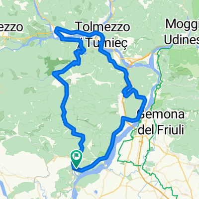
- Monte Prat - Forcella
- Distance
- 37.9 km
- Ascent
- 1,269 m
- Descent
- 1,263 m
- Location
- Forgaria nel Friuli, Friuli Venezia Giulia, Italy
- Strada di Bottecchia e lago di Cavazzo
- Distance
- 52.7 km
- Ascent
- 357 m
- Descent
- 372 m
- Location
- Forgaria nel Friuli, Friuli Venezia Giulia, Italy
- giro del Monte San Simeone
- Distance
- 51.9 km
- Ascent
- 282 m
- Descent
- 291 m
- Location
- Forgaria nel Friuli, Friuli Venezia Giulia, Italy
- Sella Chianzutan
- Distance
- 75.9 km
- Ascent
- 918 m
- Descent
- 920 m
- Location
- Forgaria nel Friuli, Friuli Venezia Giulia, Italy
Open it in the app