

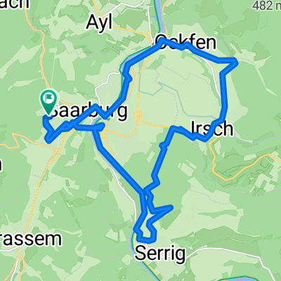
Saarburg Runde 2
A cycling route starting in Saarburg, Rhineland-Palatinate, Germany.
Overview
About this route
- -:--
- Duration
- 39.6 km
- Distance
- 606 m
- Ascent
- 611 m
- Descent
- ---
- Avg. speed
- ---
- Max. altitude
Continue with Bikemap
Use, edit, or download this cycling route
You would like to ride Saarburg Runde 2 or customize it for your own trip? Here is what you can do with this Bikemap route:
Free features
- Save this route as favorite or in collections
- Copy & plan your own version of this route
- Sync your route with Garmin or Wahoo
Premium features
Free trial for 3 days, or one-time payment. More about Bikemap Premium.
- Navigate this route on iOS & Android
- Export a GPX / KML file of this route
- Create your custom printout (try it for free)
- Download this route for offline navigation
Discover more Premium features.
Get Bikemap PremiumFrom our community
Other popular routes starting in Saarburg
 Matthäus-Merian-Straße nach Blümchesfeld
- Distance
- 23.2 km
- Ascent
- 485 m
- Descent
- 478 m
- Location
- Saarburg, Rhineland-Palatinate, Germany
 Saarburg Runde 2
- Distance
- 39.6 km
- Ascent
- 606 m
- Descent
- 611 m
- Location
- Saarburg, Rhineland-Palatinate, Germany
 Saarburg - Erbeskopf 158 km
- Distance
- 158 km
- Ascent
- 1,972 m
- Descent
- 1,968 m
- Location
- Saarburg, Rhineland-Palatinate, Germany
 Am Saarufer nach Am Saarufer
- Distance
- 32 km
- Ascent
- 95 m
- Descent
- 145 m
- Location
- Saarburg, Rhineland-Palatinate, Germany
 20170425 Saarburg zelf
- Distance
- 67.5 km
- Ascent
- 447 m
- Descent
- 448 m
- Location
- Saarburg, Rhineland-Palatinate, Germany
 van Saarburg via de oude Saar arm naar Konz
- Distance
- 34.4 km
- Ascent
- 258 m
- Descent
- 257 m
- Location
- Saarburg, Rhineland-Palatinate, Germany
 Römertempeltour
- Distance
- 41.8 km
- Ascent
- 332 m
- Descent
- 332 m
- Location
- Saarburg, Rhineland-Palatinate, Germany
 Route von Saarburg
- Distance
- 49.2 km
- Ascent
- 667 m
- Descent
- 666 m
- Location
- Saarburg, Rhineland-Palatinate, Germany
Open it in the app